
Highest elevation 266 m (873 ft) Area 29.05 km² | Highest point Agujas Grandes Population 681 (2013) | |
 | ||
Pop. density 22.17 /km (57.42 /sq mi) Points of interest Chinijo Archipelago, Playa La Francesa, Playa del Salado, Playa Montaña Amarilla, Barranco De Los Conejos | ||
Graciosa canary islands portugal vacation travel video guide
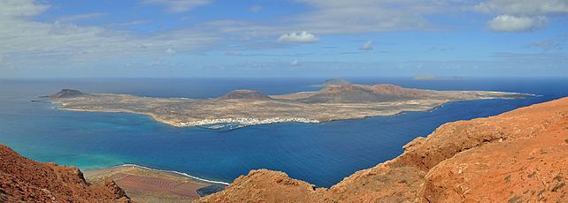
Graciosa Island or commonly La Graciosa ([la ɣɾaˈθjosa]; Spanish for "graceful") is a volcanic island in the Canary Islands of Spain, located 2 km (1.2 mi) north of the island of Lanzarote across the strait named El Río. It was formed by the Canary hotspot. The island is part of the Chinijo Archipelago and the Chinijo Archipelago Natural Park (Parque Natural del Archipiélago Chinijo). It is administrated by the municipality of Teguise. The only two settlements are Caleta de Sebo in the southeastern part of the island and summer-residence Casas de Pedro Barba.
Contents
- Graciosa canary islands portugal vacation travel video guide
- Map of Graciosa 35540 Las Palmas Spain
- The unspoilt beaches of lanzarote and la graciosa canary islands
- Geographical features
- References
Map of Graciosa, 35540, Las Palmas, Spain
The population is about 700. Tourism is the main industry along with fishing. Every year, tourists flock to the island for its tempered climate and its sandy volcanic coasts. The island has a school, lyceum, post office, supermarkets, medical center, pharmacy, a Bankia bank branch (in danger of closure as of September 2013 but still there in February 2016), port, beaches, bar-restaurants and a square.
Streets and roads on La Graciosa are unpaved sand. Motor vehicles are strictly prohibited and limited to a handful of licensed vehicles for special purposes. Access to the Island is by a 35-minute ferry crossing from Orzola on Lanzarote to the harbour in the village. There is a campsite on the Island situated on Playa del Salado at the western edge of Caleta del Sebo.
The unspoilt beaches of lanzarote and la graciosa canary islands
Geographical features
The island is extremely arid and entirely made up of bushes and dry soil. Its length is 8 km (5.0 mi) and the width is 4 km (2.5 mi), making an area of 29 km2 (11 sq mi). There are no natural water sources on the island; desalinated water has been piped directly from neighbouring Lanzarote since 2001.
There are several isolated mountains on the island, the tallest of which is Agujas Grandes rising to 266 m (873 ft). The second tallest is Agujas Chicas at 228 m (748 ft). Playa de la Cocina is a well known beach in the southwestern part of the island.