
Highest elevation 133 m (436 ft) Area 81.72 km² | Autonomous community Asturias Demonym(s) gozoniego/a Population 10,675 (2014) Local time Friday 8:19 PM | |
 | ||
Weather 12°C, Wind NE at 10 km/h, 82% Humidity | ||
Gozón is a municipality in the Autonomous Community of the Principality of Asturias, Spain, the capital of which is the village of Luanco (Lluanco). The Cantabrian Sea lies on its northern edge, and it is bordered to the south by Corvera de Asturias, to the west by Avilés, and to the east by Carreño.
Contents
Map of Goz%C3%B3n, Asturias, Spain
The municipality is a fishing port.
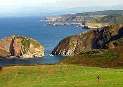
It is the location of the Cabo de Peñas (Cape of Boulders).
Toponymy
In decree 72/2005 of July 7, 2005, published in the Boletin Oficial del Principado de Asturias (BOPA; official bulletin of the Principality of Asturias) granted the Bable forms of the municipal place names official status for all uses, with the exception of the capital Lluanco/Luanco, which maintains a bilingual name. Therefore, with this exception, the Asturian names are the only ones which can appear on road signs and official maps.
Climate
As with the rest of Asturias' populated areas, Gozón has a marine climate with a narrow average high temperature range between 13 °C (55 °F) – 23 °C (73 °F). For the nearest weather station see the weather data for Gijón.