
Time zone CET (UTC+1) Area 50.43 km² Population 916 (1999) | Canton Saint-Loup-Lamairé INSEE/Postal code 79135 /79200 Local time Friday 2:08 PM | |
 | ||
Weather 10°C, Wind N at 13 km/h, 83% Humidity | ||
Gourgé is a commune in the Deux-Sèvres department in the Nouvelle-Aquitaine region in western France. It is 10 km (6.2 mi) from Parthenay.
Contents
Map of 79200 Gourg%C3%A9, France
Features
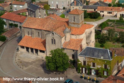
Gourgé has a ninth-century church, an old Roman bridge over the River Thouet. Famous for its fete du medieval. There is 1 bakery, Salle des Fetes, Primary School, Marie, general store and garage.
It is a delightful typically French village on one of the Compostella routes and makes a good starting point for a number of cycle and walking routes along the Thouet valley.
Gourgé is a small French village, located in the Department of Deux-Sèvres and the Nouvelle-Aquitaine region. Its inhabitants are called Gourgéens and Gourgéennes. The commune, extending to 50.4 km2, had 918 inhabitants at the last census in 2006. With a density of 18.2 inhabitants per square km, Gourgé has experienced a rise of 0.1% in its population since 1999. Surrounded by the communes of Lhoumois, Lageon and Aubigny, Gourgé is located 27 km to the south-east of Bressuire, the largest city of the area. Located at an altitude 127 meters, the Rivers Thouet and Cebron are the principal water courses which traverse the village. The commune is close to the Loire-Anjou-Touraine regional natural park approximately 40 km away. The mayor of Gourgé is Mr Gilles HAMEL.