
Admin. region Freiburg Time zone CET/CEST (UTC+1/+2) Local time Friday 12:45 PM Postal code 79288 Administrative region Freiburg | Elevation 207 m (679 ft) Area 8.74 km² Population 2,799 (31 Dec 2014) Dialling code 07665 | |
 | ||
Weather 19°C, Wind SW at 24 km/h, 45% Humidity | ||
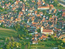
Gottenheim is an independent village at the northern tip of the Tuniberg, 15 km west of Freiburg im Breisgau. It is located in the administrative region Breisgau-Hochschwarzwald in the federal state of Baden-Württemberg, Germany.
Contents
Map of 79288 Gottenheim, Germany
Situated at an altitude of 207 m in one of the warmest regions of Germany, Gottenheim has a population of 2,500.
The total area of Gottenheim is 2183 acres (8.83 km²), which includes 275 acres (1.11 km2) of vines, 538 acres (2.18 km2) alluvial forest and some acres of half-bog.
History
Gottenheim was first officially mentioned in 1086.
Council
The last council election (Kommunalwahl) on the 13. of June 2004 lead to the following distribution of seats:
Transportation
The Breisgau S-Bahn operated Breisachbahn railway line connects Gottenheim to Breisach in the west and the national railway system (Deutsche Bahn) via Freiburg im Breisgau in the east. The Kaiserstuhlbahn connects Gottenheim to Endingen and the towns, Riegel am Kaiserstuhl, Nimburg and Bötzingen, which lay in between.
By car Gottenheim can be reached via German Autobahn A5, Frankfurt-Basel, using exit No.62 Freiburg-Mitte towards Umkirch and following signs.