
Primary outflows Stuart River Surface area 2.36 km (0.91 sq mi) Mean depth 3 m Cities Kingaroy | Primary inflows Basin countries Australia Area 229 ha | |
 | ||
Location 15 km North-West of Kingaroy, Queensland | ||
Gordonbrook Dam is the main source of water supply for Kingaroy in the Wide Bay-Burnett region of Queensland, Australia. It was built in 1941 to provide water for the Royal Australian Air Force Training Base during WWII. In 1987, due to increased demand, the dam wall was raised, and the inundated area is now 229 hectares.
Contents
- Map of Gordonbrook Dam Queensland Australia
- LandEdit
- WaterEdit
- FishingEdit
- Blue green algae infestationEdit
- References
Map of Gordonbrook Dam, Queensland, Australia
LandEdit
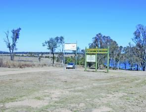
A basic picnic area is located on the eastern shores. The picnic area is fairly large and contains a composting toilet, a water tank, picnic tables, a boat ramp, information signs and a bush walk that includes an elevated lookout and a well maintained bird hide.
WaterEdit
When the lake area is open to public recreation, the dam provides a good range of water-based activities. The lake is largely accessible to small to medium-sized motorised boats, jetskis, canoes and windcraft. The body provides the best space for water skiing and water tubing, while the foot is best suited for boat fishing and non-motorised craft only, because of the large stands of dead timber.
FishingEdit
A Stocked Impoundment Permit is required to fish in all parts of the dam.
Blue green algae infestationEdit
During dry periods and because the dam's smaller size, the dam experiences high levels of blue green algae (Cyanobacteria). Activities are at the user's own risk, and the boat ramp has gates to prevent motorised craft from entering the water during times of high risk of the algae.