
Population 3,210 (2006 census) | Postcode(s) 6076 Postal code 6076 | |
 | ||
Location 25 km (16 mi) from Perth, Western Australia | ||
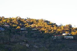
Gooseberry Hill is a suburb of Perth, Western Australia, located within the Shire of Kalamunda. It is the site of Gooseberry Hill National Park.
Map of Gooseberry Hill WA 6076, Australia
It is located at the highest point south of the departure of the Helena River from the Darling Scarp on to the Swan Coastal Plain. It is often associated with the railway formation of the Kalamunda Zig Zag, and the northern most high feature of Statham's Quarry which lie on the north west of the locality within national park land.
Gooseberry Hill was the location of a war-time tragedy when a United States Navy C-47 Skytrain (DC-3) plane crashed in heavy fog on 19 April 1945 after taking off from Guildford Airport (later Perth Airport). All of the ten US servicemen and three US Red Cross women on board were killed. The plane crashed between Gooseberry Hill Road and Lansdown Road, 4.5 miles (7.2 km) from the end of the take-off runway, having travelled in an almost straight course to the point of impact.