
Postcode(s) 4625 | Postal code 4625 | |
 | ||
Location 326 km (203 mi) N of Brisbane138 km (86 mi) W of Maryborough26 km (16 mi) NE of Gayndah | ||
Gooroolba is a locality in the Wide Bay–Burnett region of south east Queensland, Australia. The locality is in the North Burnett Region local government area 326 kilometres (203 mi) north of the state capital Brisbane.
Contents
Map of Gooroolba QLD 4625, Australia
History
The town's name is an abbreviation of the parish name of Gooroolballin, in turn named after the "Gooroolballan" sheep station. Gooroolballan station was established by at least 1857.
The extension of the Degilbo to Wetheron in 1906 brought the railway to Gooroolba. A tender was let for construction of a state school in the town in 1910.
Gooroolba Post Office opened by June 1910 (a receiving office had been open from 1907) and closed in 1973.
Gooroolba State School opened on 18 April 1911. It closed in 1964.
In 1917, a cyclone caused significant damage to the town, destroying the public hall and partially wrecking the hotel and two private stores.
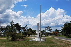
The Gooroolba War Memorial is located near the railway crossing. Originally erected to commemorate those who served in World War I, the names of those who served in World War II were added later.