
Country Serbia Settlements 24 Postal code 12223 Local time Thursday 4:09 PM | Time zone CET (UTC+1) Area 368 km² | |
 | ||
Weather 13°C, Wind W at 19 km/h, 38% Humidity | ||
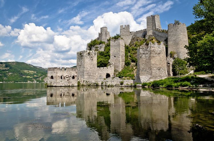
Golubac fortress day trip from belgrade serbia
Golubac (Serbian Cyrillic: Голубац, [ɡǒlubats]) is a village and municipality located in the Braničevo District of the eastern Serbia. It is situated on the right side of the Danube river. It is bordered by Romania to the east, Veliko Gradište to the west and Kučevo to the south. The population of the village is 1,655 and the population of the municipality is 8,161.
Contents
- Golubac fortress day trip from belgrade serbia
- Map of Golubac Serbia
- Mtb street view 97 golubac serbia erdap tour 1 4 08 2013
- Name
- History
- Demographics
- Tourism
- Sailing
- References
Map of Golubac, Serbia
Mtb street view 97 golubac serbia erdap tour 1 4 08 2013
Name
In Serbian, the town is known as Golubac (Голубац), in Romanian as Golumbacu Mare or Columbaci, in Hungarian as Galambóc, in German as Taubenberg and in Turkish as Güvercinlik which means "dovecote." The name Golubac is derived from golub, which is Serbian for "pigeon" or "dove," and is therefore often translated as "the town of doves."
Its historical names were Columbria, in Latin,as a contraction of (castrum) Columbaria that means city of pigeons (Latin: Columba, Greek: kòlymbos), and as a city derived from Cuppae during pre-Roman times.
History
It was a stronghold called Cuppae during Roman and Early Byzantine times (1-6th century) and turned into a city (Columbria) in 554/5 AD.
Due to many nearby archeological sites and the Đerdap national park, the village is a popular tourist, fishing and sailing destination.
The archeological sites include the remnants of one of Roman Emperor Trajan's tables near Trajan's Bridge, found along his road through the Danube's Iron Gates; and the Roman fortress Diana. Golubac fortress, 4 km downstream, is from the 14th century and also of interest. The fortress was the scene of a battle against the Turks in 1428, where the Polish knight Zawisza Czarny was captured and executed by the Turks.
From 1929 to 1941, Golubac was part of the Morava Banovina of the Kingdom of Yugoslavia.
Demographics
Ethnic groups in the Golubac municipality (2002 census):
Tourism
The Iron Gate national park is noted for its natural beauty and its hunting grounds, as well as many trails for more experienced hiking. The village's quay along the Danube river is popular for more relaxed hiking.
Sailing
Golubac has become a famous sailing site. The Sailing Center of the Sailing Association of Serbia, which the Serbian National Team uses for ground preparations before every big sailing event, is located in Golubac. One of the events is a sailing Regatta, which is traditionally held in August. During the summer, the Center holds an Optimist Class sailing camp, where beginners can learn from the best Serbian sailors and their international guests.