
OS grid reference SW607313 Post town HELSTON Local time Thursday 1:27 AM Dialling code 01736 | Sovereign state United Kingdom Postcode district TR13 | |
 | ||
Weather 9°C, Wind SE at 10 km/h, 93% Humidity | ||
Godolphin cross top 7 facts
Godolphin Cross (Cornish: Krows Hirlan) is a village in the former Kerrier District of west Cornwall, England, UK. It is in the civil parish of Breage (where the 2011 census population was included), midway between the towns of Hayle and Helston.
Contents
Map of Godolphin Cross, Helston, UK
Godolphin Cross is on an upland area, part of a geological formation known as the Tregonning-Godolphin Granite. The term refers to the plateau of high ground in this area, one of five granite batholiths in Cornwall (see Geology of Cornwall). One mile west of the village, Godolphin Hill rises to 162 metres (531 ft).
The Godolphin Estate is near the village. It is now wholly owned by the National Trust, and is undergoing extensive renovation. The whole estate and surrounding woodlands are once again open to the public, who were prevented from visiting most of the Estate by the former owners. They have now all been removed completely from the site. Godolphin Primary School serves children from 4 to 11 years and had a roll of 71 children in January 2008. It received a favourable Ofsted report in December 2006.
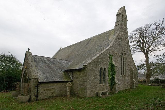
The Church of St John the Baptist is now redundant. It was designed by James Piers St Aubyn and built in 1849-50. In 2006, an application was received by Kerrier District Council to convert the church into a private dwelling.
There is a Cornish cross in the churchyard. In 1886 it was moved the churchyard having been found in use as a gatepost on the Chytodden estate.