
Population 18,690 (2006) | Area 101.4 km² | |
 | ||
Voivodeship | ||
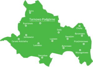
Gmina Tarnowo Podgórne is a rural gmina (administrative district) in Poznań County, Greater Poland Voivodeship, in west-central Poland. Its seat is the village of Tarnowo Podgórne, which lies approximately 19 kilometres (12 mi) north-west of the regional capital Poznań.
Contents
Map of Gmina Tarnowo Podg%C3%B3rne, Poland
The gmina covers an area of 101.4 square kilometres (39.2 sq mi), and as of 2006 its total population is 18,690.
Villages
Gmina Tarnowo Podgórne contains the villages and settlements of Baranowo, Batorowo, Ceradz Kościelny, Chyby, Góra, Jankowice, Kokoszczyn, Lusówko, Lusowo, Przeźmierowo, Rumianek, Sady, Sierosław, Swadzim, Tarnowo Podgórne and Wysogotowo.
Neighbouring gminas
Gmina Tarnowo Podgórne is bordered by the city of Poznań and by the gminas of Buk, Dopiewo, Duszniki, Kaźmierz and Rokietnica.
References
Gmina Tarnowo Podgórne Wikipedia(Text) CC BY-SA