
Population 15,993 (2006) | Area 178.8 km² | |
 | ||
Website | ||
Gmina Kożuchów is an urban-rural gmina (administrative district) in Nowa Sól County, Lubusz Voivodeship, in western Poland. Its seat is the town of Kożuchów, which lies approximately 10 kilometres (6 mi) south-west of Nowa Sól and 23 km (14 mi) south of Zielona Góra.
Contents
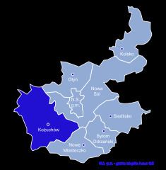
Map of Gmina Ko%C5%BCuch%C3%B3w, Poland
The gmina covers an area of 178.82 square kilometres (69.0 sq mi), and as of 2006 its total population is 15,993 (out of which the population of Kożuchów amounts to 9,592, and the population of the rural part of the gmina is 6,401).
Villages
Apart from the town of Kożuchów, Gmina Kożuchów contains the villages and settlements of Bielice, Broniszów, Bulin, Cisów, Czciradz, Drwalewice, Dziadoszyce, Dziwiszowice, Kierzkowice, Książ Śląski, Lasocin, Mirocin Dolny, Mirocin Górny, Mirocin Średni, Podbrzezie Dolne, Podbrzezie Górne, Radwanów, Słocina, Sokołów, Solniki, Studzieniec, Stypułów, Wolnica and Zawada.
Neighbouring gminas
Gmina Kożuchów is bordered by the gminas of Brzeźnica, Nowa Sól, Nowe Miasteczko, Nowogród Bobrzański, Otyń, Szprotawa and Zielona Góra.