
Population 10,424 (2014) | County Kołobrzeg Area 144.8 km² | |
 | ||
Voivodeship | ||
Gmina ko obrzeg d wirzyno tereny inwestycyjne ul piastowska wyzwolenia
Gmina Kołobrzeg is a rural gmina (administrative district) in Kołobrzeg County, West Pomeranian Voivodeship, in north-western Poland. Its seat is the town of Kołobrzeg, although the town is not part of the territory of the gmina.
Contents
- Gmina ko obrzeg d wirzyno tereny inwestycyjne ul piastowska wyzwolenia
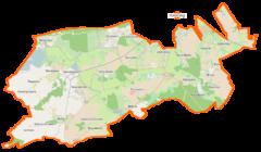
- Map of Gmina KoC582obrzeg Poland
- Gmina ko obrzeg d wirzyno cie ka zdrowia w lesie nadmorskim
- Villages
- Neighbouring gminas
- References
Map of Gmina Ko%C5%82obrzeg, Poland
The gmina covers an area of 144.75 square kilometres (55.9 sq mi), and as of 2014 its total population is 10,424.
Gmina ko obrzeg d wirzyno cie ka zdrowia w lesie nadmorskim
Villages
Gmina Kołobrzeg contains the villages and settlements of Bezpraw, Błotnica, Bogucino, Bogusławiec, Budzimskie, Budzistowo, Drzonowo, Dźwirzyno, Głąb, Głowaczewo, Grzybowo, Kądzielno, Karcino, Kopydłówko, Korzyścienko, Korzystno, Niekanin, Nowogardek, Nowy Borek, Obroty, Przećmino, Przylaski, Rogozina, Samowo, Sarbia, Sieradowo, Sobiemierz, Stary Borek, Stramnica, Świerszczewo, Wólka and Zieleniewo.
Neighbouring gminas
Gmina Kołobrzeg is bordered by the town of Kołobrzeg and by the gminas of Dygowo, Gościno, Siemyśl, Trzebiatów and Ustronie Morskie.