
Population 3,658 (2011) | Area 128.5 km² | |
 | ||
Gmina Grabowo is a rural gmina (administrative district) in Kolno County, Podlaskie Voivodeship, in north-eastern Poland. Its seat is the village of Grabowo, which lies approximately 15 kilometres (9 mi) east of Kolno and 78 km (48 mi) north-west of the regional capital Białystok.
Contents
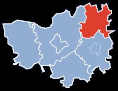
Map of Gmina Grabowo, Poland
The gmina covers an area of 128.48 square kilometres (49.6 sq mi), and as of 2006 its total population is 3,637 (3,658 in 2011).
Villages
Gmina Grabowo contains the villages and settlements of Andrychy, Bagińskie, Borzymy, Chełchy, Ciemianka, Dąbrowa, Gałązki, Gnatowo, Golanki, Grabowo, Grabowskie, Grądy-Michały, Grądy-Możdżenie, Guty Podleśne, Jadłówek, Kamińskie, Konopki-Białystok, Konopki-Monety, Kownacin, Kurkowo, Łebki Duże, Łebki Małe, Łubiane, Marki, Milewo-Gałązki, Pasichy, Przyborowo, Rosochate, Siwki, Skroda Wielka, Stare Guty, Stawiane, Surały, Świdry Podleśne, Świdry-Dobrzyce, Wiszowate, Wojsławy and Żebrki.
Neighbouring gminas
Gmina Grabowo is bordered by the gminas of Biała Piska, Kolno, Przytuły, Stawiski, Szczuczyn and Wąsosz.