
Province Ulster | ||
 | ||
Similar Binevenagh, Roe Valley Country Park, Slieve Gallion, Lougher, Dungiven Castle | ||
Around the place glenshane pass northern ireland
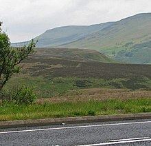
The Glenshane Pass (from Irish Gleann Seáin, meaning 'Shane's valley') is a major mountain pass cutting through the Sperrin Mountains in County Londonderry, Northern Ireland. It is in the townland of Glenshane Pass on the main Derry to Belfast route, the A6.
Contents
- Around the place glenshane pass northern ireland
- Map of Glenshane Pass Londonderry UK
- Features
- History
- The Troubles
- References
Map of Glenshane Pass, Londonderry, UK
Features
It is a Special Area of Conservation. Carn/Glenshane Pass is a large area of intact blanket bog, characterised by undulating topography and including a large, well-developed hummock and pool system within a thick mantle of blanket peat. It is also classed as an Area of Special Scientific Interest. The Ponderosa is claimed as being the highest public house in the island of Ireland, situated 946 feet (288 metres) above sea level.
History
The Glenshane Pass is claimed as being named after Shane Crossagh Ó Maoláin a notorious rapparee, or highwayman, who roamed the highways of County Londonderry and County Tyrone in the late seventeenth and early eighteenth century.