
Coat of arms Flag selsoviet 16 Area 2,160 km² | Rural localities 123 Founded 15 June 1929 | |
 | ||
Glazovsky District (Russian: Гла́зовский райо́н; Udmurt: Глаз ёрос) is an administrative and municipal district (raion), one of the twenty-five in the Udmurt Republic, Russia. It is located in the north of the republic. The area of the district is 2,159.7 square kilometers (833.9 sq mi). Its administrative center is the city of Glazov (which is not administratively a part of the district). Population: 17,132 (2010 Census); 18,792 (2002 Census); 19,161 (1989 Census).
Contents
- Map of Glazovsky District Udmurt Republic Russia
- Geography
- Administrative and municipal status
- Demographics
- References
Map of Glazovsky District, Udmurt Republic, Russia
Geography
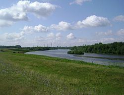
The Cheptsa River flows through the central parts of the district. Other significant rivers include the Pyzel, the Ubyt, the Sepych, and the Varyzh.
Administrative and municipal status
Within the framework of administrative divisions, Glazovsky District is one of the twenty-five in the republic. The city of Glazov serves as its administrative center, despite being incorporated separately as a city of republic significance—an administrative unit with the status equal to that of the districts.
As a municipal division, the district is incorporated as Glazovsky Municipal District. The city of republic significance of Glazov is incorporated separately from the district as Glazov Urban Okrug.
Demographics
Ethnic composition (according to the 2002 Census): Udmurt people: 79%; Russians: 17.4%; Tatars: 2%; others: 1.6%.