
Elevation 8,875 ft (2,705 m) | ||
 | ||
Similar Mühlig‑Hofmann Mountains, Jutulsessen, Mount Hochlin, Hoggestabben Butte, Jøkulkyrkja Mountain | ||
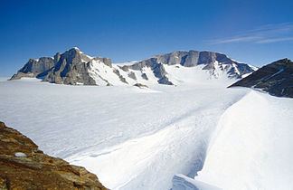
The Gjelsvik Mountains are a group of mountains about 25 nautical miles (50 km) long, between the Sverdrup Mountains and the Mühlig-Hofmann Mountains in Queen Maud Land, East Antarctica. With its summit at 2,705 metres (8,875 ft), the massive Risemedet Mountain forms the highest point in these mountains, also marking their eastern end.
Discovery and naming
The Gjelsvik Mountains were first photographed from the air and roughly plotted by the Third German Antarctic Expedition (1938–39). They were mapped in detail by Norwegian cartographers from surveys and air photos by the Norwegian–British–Swedish Antarctic Expedition (1949–52) and from air photos by the Norwegian expedition (1958–59). They were named for Tore Gjelsvik, Director of the Norwegian Polar Institute.