
Time zone CET (UTC+1) Population 7,372 (1999) | Canton Givet Area 18.41 km² Local time Tuesday 12:16 PM | |
 | ||
Weather 13°C, Wind SW at 11 km/h, 61% Humidity Points of interest Centre Européen des Métiers d'Art | ||
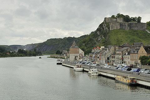
Givet ([ʒi.vɛ]) is a commune in the Ardennes department in northern France very close to the Belgian border. It lies on the river Meuse where Emperor Charles V built the fortress of Charlemont. It borders the French municipalities of Fromelennes to the east and Rancennes to the south and Foisches to the southeast.
Contents
Map of 08600 Givet, France
Later on, another building was added to the fort, the Caserne Rougé, the longest barracks of France at that time, named after Pierre François, Marquis de Rougé, general of the French armies k.a. 1761.
History
The town's history claims that Saint Hubert lived there in 720 and performed a miracle. The town has changed hands several times since the Roman era before becoming part of France in 1678, and was later invaded by Russians and Germans.
In World War II, Givet was occupied by the Germans on May 12, 1940. The city was liberated September 7, 1944. By December 1944, 11,000 American soldiers were billeted in the ancient Charlemont fortress. The German Ardennes Offensive targeted Givet and its crossing of the Meuse. The British, under Montgomery, organized a last-ditch defense, and on 24 December, the German drive was stopped about 10 kilometers from Givet.