
Country France Area 16.67 km² | Canton Gisors Population (2008) 11,681 Local time Tuesday 9:35 AM | |
 | ||
Weather 6°C, Wind W at 6 km/h, 100% Humidity Points of interest Château de Gisors, Lavoir de Gisors, Chapelle de la Léproseri | ||
Gisors is a commune of Normandy, France. It is located 62.9 km (39.1 mi) northwest from the centre of Paris.
Contents
Map of 27140 Gisors, France
Gisors, together with the neighbouring communes of Trie-Château and Trie-la-Ville, form an urban area of 12,669 inhabitants (1999 census). This urban area is a satellite town of Paris.
Geography
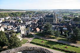
Gisors is located in the Vexin normand region of Normandy at the confluence of the Epte, Troesne and Réveillon rivers .
Transport
The Gisors-Embranchement station is the terminus of a Transilien suburban rail service from the Paris Saint-Lazare station.
Sights
References
Gisors Wikipedia(Text) CC BY-SA