
Website www.gilescounty.org Founded 1806 | Area 932.4 km² Population 16,925 (2013) | |
 | ||
Rivers New River, Sinking Creek, Dismal Creek, Wolf Creek Points of interest Cascade Falls, Mountain Lake, Mountain Lake Wilderness, Giles County Historical, Wind Rock | ||
Angels rest appalachian trail hiking near pearisburg giles county virginia
Giles County is a county located in the U.S. state of Virginia. As of the 2010 census, the population was 17,286. Its county seat is Pearisburg.
Contents
- Angels rest appalachian trail hiking near pearisburg giles county virginia
- Map of Giles County VA USA
- Welcome to giles county virginia
- History
- Geography
- Adjacent counties
- National protected area
- Major highways
- Railroads
- Demographics
- Board of Supervisors
- Constitutional Officers
- Towns
- Education
- References
Map of Giles County, VA, USA
Giles County is included in the Blacksburg-Christiansburg-Radford, VA Metropolitan Statistical Area.
Giles County is the location of Mountain Lake, one of only two natural fresh water lakes in Virginia. The Lake drains into Little Stony Creek, which passes over "The Cascades", a spectacular waterfall, before reaching the New River.
Welcome to giles county virginia
History
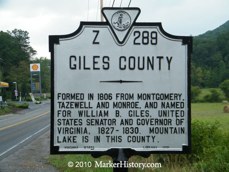
Giles County was established in 1806 from Montgomery, Monroe, Wythe, and Tazewell counties. The county is named for William Branch Giles who was born in Amelia County in 1762. Giles became a lawyer and from there was elected to the United States House of Representatives where he served from 1790 to 1815. He also served in the Virginia General Assembly from 1816 to 1822. In 1827, he was elected Governor. In all, he served his nation and state around a total of forty years.
Geography
According to the U.S. Census Bureau, the county has a total area of 360 square miles (930 km2), of which 356 square miles (920 km2) is land and 4.6 square miles (12 km2) (1.3%) is water.
Adjacent counties
National protected area
Major highways
Railroads
Demographics
As of the census of 2010, there were 17,286 people, 7,215 households, and 4,899 families residing in the county. The population density was 48 people per square mile (18/km²). There were 8,319 housing units at an average density of 23 per square mile (9/km²). The racial makeup of the county was 96.74% White, 1.51% Black or African American, 0.12% Native American, 0.32% Asian, 0.36% from other races, and 0.95% from two or more races. 1.21% of the population were Hispanic or Latino of any race.
There were 7,215 households out of which 29.27% had children under the age of 18 living with them, 52.46% were married couples living together, 10.49% had a female householder with no husband present, and 32.10% were non-families. 27.86% of all households were made up of individuals and 12.56% had someone living alone who was 65 years of age or older. The average household size was 2.38 and the average family size was 2.88.
In the county, the population was spread out with 22.70% under the age of 18, 4.89% from 20 to 24, 23.85% from 25 to 44, 29.43% from 45 to 64, and 18.03% who were 65 years of age or older. The median age was 43 years. For every 100 females there were 96.14 males. For every 100 females age 18 and over, there were 93.55 males.
The median income for a household in the county was $45,231, and the median income for a family was $53,750. Males had a median income of $41,521 versus $36,886 for females. The per capita income for the county was $23,766. About 6.60% of families (2000 census) and 12.7% of the population were below the poverty line(2012), including 17.70% of those under age 18 (2012)and 10.50% of those age 65 or over (2000 census).
Board of Supervisors
At-Large District: Paul W. "Chappy" Baker (I)
At-Large District: Richard "Ricky" McCoy (I)
Central District: Barbara M. Hobbs (I)
Eastern District: Larry "Jay" Williams (I)
Western District: B. Scott Dunn (I)
Constitutional Officers
Clerk of the Circuit Court: C.L. "Bubbie" Fraley, III (I)
Commissioner of the Revenue: Lisa Corell (I)
Commonwealth's Attorney: Robert M. Lilly, Jr. (I)
Sheriff: W. Morgan Millirons (I)
Treasurer: Gerald W. Duncan (I)
Giles is represented by Democrat John S. Edwards in the Virginia Senate, Republican Joseph R. Yost in the Virginia House of Delegates, and Republican H. Morgan Griffith in the U.S. House of Representatives.
Towns
Giles County has five incorporated towns. Only nine other counties have more towns than Giles. Of the 191 towns in Virginia, Glen Lyn is the fifth smallest in population. Thirty-nine percent of Giles residents live in one of the five towns.
Education
Giles county is home to three public elementary/middle schools and two public high schools:
The schools have a combined enrollment of 2425 as of mid 2014.