
River mouth Agout285 m (935 ft) Length 50 km Mouth Agout | Basin size 208 km (80 sq mi) Basin area 208 km² | |
 | ||
Main source Lacaune745 m (2,444 ft) Discharge Average rate:4.63 m/s (164 cu ft/s) | ||
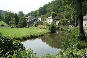
The Gijou (French: le Gijou) is a 50.2 km (31.2 mi) long river in the Tarn département, southwestern France. Its source is at Lacaune. It flows generally west-southwest. It is a right tributary of the Agout into which it flows at Vabre.
Contents
Map of Le Gijou, France
Communes along its course
This list is ordered from source to mouth: Lacaune, Gijounet, Viane, Lacaze, Saint-Pierre-de-Trivisy, Vabre
References
Gijou Wikipedia(Text) CC BY-SA