
Length 13 km (8.1 mi) Population Uninhabited Area 22 km² | Width 2 km (1.2 mi) Ethnic groups None | |
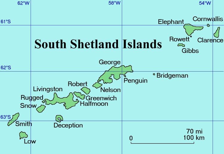 | ||
Gibbs Island lies 25 km (16 mi) south-west of Elephant Island in the South Shetland Islands of Antarctica. James Weddell, whose chart of the islands appeared in 1825, was apparently the first to use the current name.
Contents
Map of Gibbs Island, Antarctica
Description
Gibbs is a slender, east-west aligned island, some 13 km (8.1 mi) long, 2 km (1.2 mi) wide and 22 km2 (8 sq mi) in area. It is bordered to the south by Bransfield Strait and to the north by the Loper Channel. The isthmus of The Spit joins the main part of Gibbs Island in the west to Furse Peninsula in the east.
Important Bird Area
A 369 ha tract of land comprising Furse Peninsula, The Spit and a small ice-free area on Gibbs Island west of The Spit has been identified as an Important Bird Area (IBA) by BirdLife International because it supports breeding colonies of about 1700 pairs of macaroni and 190 pairs of chinstrap penguins, as well as over 18,000 pairs of southern fulmars.
Tomb
The tomb of a German sailor can be found on Gibbs Island. The epitaph on the cross of the sumptuous grave reads: "Wilhelm Tolz, Matrose aus Husum, 1875 - 1912. Durch fremde Hand ertrunken. Ruhe in Frieden". (English: "Wilhelm Tolz, Sailor from Husum, 1875-1912. Drowned through alien/strange hand. Rest in peace.") Nothing more is known about this person and his death.