
Elevation 45 m (148 ft) Area code(s) +53-24 Local time Monday 1:56 PM | Established 1817 Time zone EST (UTC-5) Area 630 km² | |
 | ||
Weather 29°C, Wind NE at 21 km/h, 58% Humidity | ||
Gibara ([xiˈβaɾa]) is a town and municipality of the Province of Holguín in the Republic of Cuba.
Contents
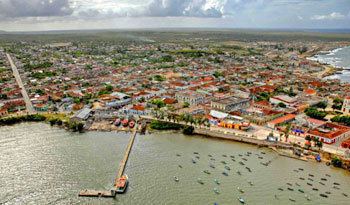
Map of Gibara, Cuba
Overview
The main city was founded on January 16, 1817. It is also known as "The White Town", Spanish: La Villa Blanca. Gibara has a beautiful and breezy landscape, and also possesses excellent architectural designs and a well-planned layout of its streets, houses and parks. Even so, Gibara's biggest asset, according to visitors, are its people, which are described as cooperative, friendly, affectionate, and proud of their village and of its history. It is said Admiral Christopher Columbus had remarked of Gibara's environs that “it is the most beautiful land that human eyes saw.”
"The White Villa" in Gibara, although small, is said to possess a peculiar charm, exhibiting an architectural patrimony reflecting almost two centuries of history, as well as its people's cultural roots.
Currently, some controversy exists about whether it was the Bay of Gibara or the Bay of Bariay that Admiral Christopher Columbus' ships reached during his first voyage to Cuba.
Gibara was declared a National Monument in 2002; additionally, since 2003, the International Festival of Poor Cinema, where films are presented in a number different categories, has been held in this small coastal city.
Demographics
In 2004, the municipality of Gibara had a population of 72,810. With a total area of 630 km2 (240 sq mi), it has a population density of 115.6/km2 (299/sq mi).
The municipality is divided into the barrios of Arroyo Blanco, Blanquizal, Bocas, Candelaria, Cantimplora, Cupeycillos, Palmita, Rabón.