
 | ||
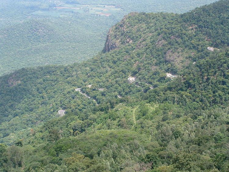
Ghat Roads are access routes into the mountainous Western and Eastern Ghats mountain ranges of the Indian Subcontinent. These roads are remarkable feats of engineering and most date back to British times. Ghat roads were built to connect to the famous Hill Stations of the Indian Subcontinent.
Contents
- Map of Sree Venkateswara Ghat Rd Tirupati Andhra Pradesh
- Tirumala ghat roads
- Karnataka
- Nilgiri Ghat Roads
- Kodai Ghat Road
- Yelagiri Ghat Road
- Yercaud Ghat Road
- Kollimalai Ghat Road
- Valparai Ghat Road
- Dhimbam Ghat Road
- References
Map of Sree Venkateswara Ghat Rd, Tirupati, Andhra Pradesh
There are many roads in India which can be classed as Ghat Roads.
Tirumala ghat roads
The Ghat roads between Tirupati and Tirumala to pilgrim Tirumala Venkateswara Temple. They are in Seshachalam Hills range in Pūrva Ghaṭ
Karnataka
The state of Karnataka in Bharat (India) has most of ghat roads in Western Ghat region. The Western Ghat lies between coastal plains adjoing Arabian Sea and Deccan Plateau. There are many ghat roads which connect Karavali districts with that of Malenadu and Bayaluseemae region. Most of these ghats are very scenic during monsoon ( rainy ) season in the months of June, July and August.A few of them are mentioned below.
Agumbe (Kannada: ಆಗುಂಬೆ) is a small village located in Shimoga district, Thirthahalli taluk ... below Agumbe. Fog filled valley, Sunset point. Agumbe lies in a hilly, wet region of the Western Ghat mountains. Agumbe connects Udupi district ( Udipi) with Shivamogga ( Shimoga ).
Charmadi . Charmadi ghat lies on border of Dakshina Kannada and Chicmagalore districts of Karunadu. The national highway NH-73 ( Old NH-234 ) passes through this ghat.
Shiradi. Shirady ghat connects coastal district of Dakshina Kannada with Hassan district. The National highway 75 ( Old NH-48 ) road starts from sea port city of Mangaluru in Dakshina Kannada district with Karnataka state capital Bengaluru.
Hulikal. Hulikal ghat or Balebare ghat connects Udupi district with Shivamogga district both in Karnataka state of India ( Bharath ). The ghat is pass for movement of people and vehicles from low-lying coastal region to Deccan plateau through Western ghats.
Sampaje. Sampaje ghat road is a part of Mangalooru to Mysuru highway.
Bisle. Bisle ghat road connects temple town of Kukke Subramanya in Dakshina Kannada district which lies below western ghats to Sakleshpura above the western ghats. This ghat road is less used because of elephant menace. The Bisle ghat road lies in the Elephant corridor of Western Ghats.
Nilgiri Ghat Roads
They are situated in The Nilgiris District of Tamil Nadu. There are several ghat roads here.
Kodai Ghat Road
Also known as the state highway SH 156 to reach the Kodaikanal hill station, situated in Dindigul District in Tamil Nadu.
Yelagiri Ghat Road
It is situated in Vellore district and has 14 hairpin bends through 15 kilometres (9.3 mi). Ghat road begins at Ponneri village which lies in Vaniyambadi-Tirupattur Road.
Yercaud Ghat Road
This includes 20 sharp hairpin bends along 25 kilometres (16 mi) ghat road. This hill station is in Salem District.
Kollimalai Ghat Road
This road contains 70 hairpin bends and leads to this wonderful hill station which is situated in Namakkal district. The ghat road begins in Belukurichi village at the foot of the Kollimalai hills. Ghat road covers 24 kilometres (15 mi).
Valparai Ghat Road
The Ghat road begins at the Monkey Falls and has 40 hairpin bends. Valparai is a hill station in Coimbatore district.
Dhimbam Ghat Road
This 14 kilometres (8.7 mi) ghat road located close to Eastern Ghats extends from Bannari to Dhimbam is a part of NH 948 cutting across Sathyamangalam Wildlife Sanctuary. 27 Hairpin bends.