
Elevation 229 m | Region Punjab Province Time zone PKT (UTC+5) Area code 0544 | |
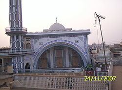 | ||
Gharmala (Urdu:گھرمالہ ) is a village located in Jhelum District, Punjab, Pakistan. It is part of Jhelum Tehsil, and is located at N 32° 57' 0 E 73° 41' 0 at an altitude of 229 metres (754 feet). and lies along the famous Rohtas Road. The village is about 3 km west of the city of Jhelum and has a population of over 5,000. It has girls' and boys' high schools. There are two mosques in village.
Contents
Map of Gharmala, Pakistan
Geography and climate
The village lies at the foot of Pothohar Plateau and the ground is fairly plain. It experiences all four seasons. Summer is really hot and thr temperature can reach above 48 °C during June and July. The monsoon starts in the middle of July lasts for 4 to 6 weeks. Winters are mostly dry and cold but December is relatively wet and temperature can fall below 0 °C. .
Transport
Gharmala is well-connected by different roads to other villages and to Jhelum city. Jhelum Railway Station is about 2.5 km and GT road is 2 km. Rohtas Road passes by the village on the south which leads to Jhelum City on east and to Rohtas Fort on the west. It is old track of the GT Road.