
Country United States County Scotts Bluff Time zone Mountain (MST) (UTC-7) Elevation 1,192 m Local time Sunday 2:10 PM | Founded 1887 Area code(s) 308 Zip code 69341 Population 8,480 (2013) | |
 | ||
Weather 10°C, Wind NW at 39 km/h, 44% Humidity | ||
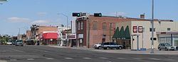
Gering is a city in Scotts Bluff County, Nebraska, United States. The population was 8,500 at the 2010 census. It is the county seat of Scotts Bluff County.
Contents
- Map of Gering NE 69341 USA
- History
- Geography
- Demographics
- 2010 census
- 2000 census
- Major events
- Notable people
- Points of interest
- References
Map of Gering, NE 69341, USA
History
Gering was founded in 1887 at the base of the bluff that is now the center of Scotts Bluff National Monument. It was named for Martin Gering, a pioneer merchant. The city of Scottsbluff was founded across the North Platte River from the bluff in 1900. Separated only by the river, the two cities have since grown together and now form the 7th largest urban area in Nebraska.
Geography
Gering is located at 41°49′27″N 103°39′54″W (41.824251, -103.665009). According to the United States Census Bureau, the city has a total area of 4.30 square miles (11.14 km2), all of it land.
Demographics
Gering is part of the Scottsbluff, Nebraska Micropolitan Statistical Area.
2010 census
As of the census of 2010, there were 8,500 people, 3,361 households, and 2,278 families residing in the city. The population density was 1,976.7 inhabitants per square mile (763.2/km2). There were 3,601 housing units at an average density of 837.4 per square mile (323.3/km2). The racial makeup of the city was 89.6% White, 0.6% African American, 1.5% Native American, 0.4% Asian, 0.1% Pacific Islander, 5.5% from other races, and 2.4% from two or more races. Hispanic or Latino of any race were 17.2% of the population.
There were 3,361 households of which 32.8% had children under the age of 18 living with them, 52.8% were married couples living together, 11.5% had a female householder with no husband present, 3.5% had a male householder with no wife present, and 32.2% were non-families. 28.1% of all households were made up of individuals and 14.7% had someone living alone who was 65 years of age or older. The average household size was 2.45 and the average family size was 2.99.
The median age in the city was 38.7 years. 25.6% of residents were under the age of 18; 7.4% were between the ages of 18 and 24; 23.5% were from 25 to 44; 26.3% were from 45 to 64; and 17.1% were 65 years of age or older. The gender makeup of the city was 46.9% male and 53.1% female.
2000 census
As of the census of 2000, there were 7,751 people, 3,173 households, and 2,170 families residing in the city. The population density was 2,067.8 people per square mile (798.0/km²). There were 3,332 housing units at an average density of 888.9 per square mile (343.1/km²). The racial makeup of the city was 91.48% White, 0.13% African American, 1.14% Native American, 0.25% Asian, 0.04% Pacific Islander, 5.56% from other races, and 1.41% from two or more races. Hispanic or Latino of any race were 13.40% of the population.
There were 3,173 households out of which 31.4% had children under the age of 18 living with them, 55.3% were married couples living together, 10.4% had a female householder with no husband present, and 31.6% were non-families. 28.5% of all households were made up of individuals and 14.9% had someone living alone who was 65 years of age or older. The average household size was 2.39 and the average family size was 2.93.
In the city, the population was spread out with 24.6% under the age of 18, 8.1% from 18 to 24, 25.0% from 25 to 44, 23.8% from 45 to 64, and 18.6% who were 65 years of age or older. The median age was 40 years. For every 100 females there were 87.9 males. For every 100 females age 18 and over, there were 85.1 males.
As of 2000 the median income for a household in the city was $35,185, and the median income for a family was $42,378. Males had a median income of $32,750 versus $22,026 for females. The per capita income for the city was $18,775. About 5.9% of families and 7.8% of the population were below the poverty line, including 8.3% of those under age 18 and 7.4% of those age 65 or over.
Major events
In 1922, Gering started its annual Oregon Trail Days, a celebration that takes place during the second week of July each year. Friends, families, Gering High School classmates, and the Old Settlers reunion all congregate in Gering for a weekend full of activities.
The Oregon Trail Days weekend kicks off with the community barbecue on Thursday night. Friday morning is the Annual Kiddie Parade on 10th Street, with the International Food Fair in Downtown Gering Friday night. Saturday morning the community gathers for the annual Oregon Trail Days Parade. This is followed by the annual Chili-Cookoff in Oregon Trail Park, and a concert at Five Rocks Amphitheater on Saturday evening.