
Length 138.1 km | ||
 | ||
North end: SR 32 northeast of Albany Counties Seminole County, Georgia, Miller County, Georgia, Baker County, Georgia, Dougherty County, Georgia, Lee County | ||
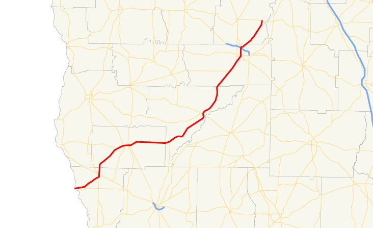
State Route 91 (SR 91) is a 85.8-mile-long (138.1 km) south–north state highway in the southwest part of the U.S. state of Georgia. The highway travels from its southern terminus at the Florida state line, southwest of Donalsonville, where the roadway continues as State Road 2, northeast through Albany to its northern terminus, an intersection with SR 32 at a point northeast of the city.
Contents
- Map of GA 91 Georgia USA
- Route description
- Donalsonville alternate route
- Colquitt truck route
- Colquitt spur
- References
Map of GA-91, Georgia, USA
Route description
SR 91 begins at the Florida state line, where the roadway continues as State Road 2. Just east of the state line, the route intersects with SR 285. Northeast, in Donalsonville, the route intersects US 84/SR 38/SR 39. The four routes share a very brief concurrency through the city. Just prior to leaving the city, SR 39 departs the concurrency to the south, while SR 91 departs to the north. Southwest of Colquitt, is an intersection with SR 273. Just west of the city, SR 91 intersects SR 45. The two routes begin a concurrency to the northeast. Just after that, the three routes intersect US 27/SR 1. The three-route concurrency heads east to Colquitt. In the city, US 27/SR 1 depart to the southeast, while SR 45/SR 91 continue to the east. Just to the east, SR 45 departs to the north, while SR 91 heads east. SR 91 heads northeast to an intersection with SR 253. The route heads northeast to Newton. In Newton, the route intersects SR 37 and SR 200. Just southwest of Albany, SR 91 intersects SR 62. In the city, is an intersection with SR 234. Farther into the city, is an intersection with US 19 BUS/US 82 BUS/SR 520 BUS. Just before leaving Albany, the route intersects the Liberty Expressway (US 19/US 82/SR 3/SR 133/SR 520). SR 91 heads northeast until it reaches its northern terminus, at an intersection with SR 32. The roadway continues as Philema Road North.
Donalsonville alternate route
State Route 91 Alternate (SR 91 Alternate) begins at an intersection with the SR 91 mainline, in the southern part of Donalsonville. It heads north to an intersection with US 84/SR 38. It heads north, then turns northeast, until it intersects SR 39. It heads northeast, turns north, and then heads northeast again until it meets its northern terminus, another intersection with the SR 91 mainline.
Colquitt truck route
State Route 91 Truck (SR 91 Truck) is a 1.1-mile-long (1.8 km) truck route that exists entirely within the central part of Miller County. Its route travels totally within the city limits of Colquitt. It is concurrent with SR 45 Truck for nearly its entire length.
It begins at an intersection with US 27/SR 1/SR 45/SR 91 (West Crawford Street) in the central part of the city, at a point where SR 45 and SR 91 end a concurrency with US 27/SR 1. This intersection is also the southern terminus of SR 45 Truck, which begins a concurrency with SR 91 Truck. US 27/SR 1/SR 45 Truck/SR 91 Truck travels to the southeast and curves to the east. They intersect the southern terminus of SR 45 Conn. (South First Street). The concurrency curves again to the southeast and intersect the southern terminus of SR 91 Spur, where the truck routes leave US 27/SR 1. SR 45 Truck/SR 91 Spur/SR 91 Truck travels to the northeast and curves to a nearly due north direction. At an intersection with SR 91 (Main Street), SR 91 Spur and SR 91 Truck end, while SR 45 Truck turns left onto SR 91.
SR 45 Truck is not part of the National Highway System, a system of roadways important to the nation's economy, defense, and mobility.
The entire route is in Colquitt, Miller County.
Colquitt spur
State Route 91 Spur (SR 91 Spur) is a 0.3-mile-long (0.48 km) spur route. It is entirely concurrent with SR 45 Truck and SR 91 Truck. Its southern terminus is at US 27/SR 1 (Crawford Street) in the central part of Colquitt. This intersection is where SR 45 Truck and SR 91 Truck end their concurrency with US 27/SR 1. The three highways travel to the northeast and curve to a nearly due north direction. At an intersection with SR 91 (Main Street), SR 91 Spur and SR 91 Truck end, and SR 45 Truck turns left onto SR 91.
The entire route is in Colquitt, Miller County.