
Length 43 km | ||
 | ||
Counties | ||
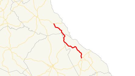
State Route 79 (SR 79) is a state highway in the east-central part of the U.S. state of Georgia. The highway runs 26.7 miles (43.0 km) from Lincolnton northwest to a point southeast of Elberton.
Contents
Map of GA-79, Georgia, USA
Route description
SR 79 begins at an intersection with US 378/SR 43 in Lincolnton. South of the intersection, the roadway continues as Goshen Street. In Chennault, the route intersects SR 44. The highway continues heading northwest to its northern terminus, an intersection with SR 72 southeast of Elberton.
References
Georgia State Route 79 Wikipedia(Text) CC BY-SA