
Length 41.4 km | ||
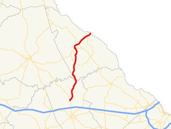 | ||
State Route 43 (SR 43) is a 25.7-mile-long (41.4 km) state highway that runs southwest-to-northeast through portions of McDuffie and Lincoln counties in the east-central part of the U.S. state of Georgia. The route connects the northern part of the Thomson area to the South Carolina state line, via Lincolnton.
Contents
Map of GA-43, Lincolnton, GA 30817, USA
Route description
SR 43 beins at an intersection with US 78/SR 10/SR 17 (Washington Road) north of Thomson in McDuffie County. It heads north-northeast, crossing over the Little River on the Raysville Bridge. On this bridge, it crosses into Lincoln County just east of the meeting point of McDuffie, Wilkes, and Lincoln counties. It continues to the north-northeast, and intersects SR 220 in the southern portion of the county, just south-southwest of Loco. It continues its routing and curves to the northwest into Lincolnton. In town, SR 43 intersects SR 47 (Elm Avenue). The two routes travel concurrent for about 600 feet (180 m) to the west. Farther to the west, they meet US 378. At this intersection, SR 43 and SR 47 diverge; SR 43 runs concurrent with US 378 eastbound, and SR 47 runs concurrent with US 378 westbound. US 378/SR 43 remain concurrent to the South Carolina state line, where SR 43 meets its northern terminus and US 378 continues to McCormick, South Carolina.
SR 43 is not part of the National Highway System, a system of roadways important to the nation's economy, defense, and mobility.