
Length 135.7 km | ||
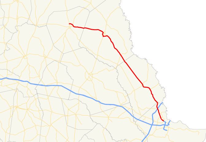 | ||
State Route 21 (SR 21) is a 84.4-mile-long (135.8 km) state highway that travels southeast-to-northwest through portions of Chatham, Effingham, Screven, and Jenkins counties in the eastern part of the U.S. state of Georgia. The highway connects the Savannah and Millen areas, via Springfield and Sylvania. The highway is part of the Savannah River Parkway and is being considered for inclusion into Interstate 3 (I-3), a future Interstate Highway proposed to connect the Savannah and Knoxville, Tennessee areas.
Contents
- Map of GA 21 Georgia USA
- Route description
- Tom Triplett Parkway
- National Highway System
- Future
- Garden City spur route
- Springfield spur route
- Newington business loop
- Sylvania business loop
- References
Map of GA-21, Georgia, USA
Route description
SR 21 begins at an intersection with SR 204 (Abercorn Street) in Savannah. The highway travels to the west-northwest, becoming a freeway, and gains the designation of Interstate 516 (I-516) and the unsigned SR 421. The highways continue to the west-northwest, then curve to the north-northeast at the interchange with Veterans Parkway. At exit 3, US 17/SR 25 join the freeway from the southwest, and US 80/SR 26 join the freeway from the northeast. Continuing to the north-northeast, the highways have an interchange with I-16, at which point, US 17 departs to the east-southeast, concurrent with I-16. At exit 7, US 80/SR 26 depart to the west-northwest, and the highways turn to the west-northwest. After an interchange with SR 25, I-516/SR 421 end, and SR 21 continues its northwestward route. In Port Wentworth, SR 30 joins the route; north of their interchange with I-95, SR 30 departs to the west-southwest.
SR 21 continues north, leaving Chatham County and entering Effingham County. The highway travels through Rincon and Springfield, then continues northwest, through rural parts of the county, and continues into Screven County. After a brief concurrency with US 301/SR 73 Loop around the western side of Sylvania, SR 21 continues west into Jenkins County. East of Millen, SR 21 turns to the northwest at its intersection with SR 67, then arcs to the northeast of Millen to meet its northern terminus at US 25/SR 121.
Tom Triplett Parkway
The Tom Triplett Parkway is a section of SR 21 located in Port Wentworth on the west side of the Savannah metropolitan area.
It stretches from the Chatham–Effingham county line (roughly the Lake Cherie Road intersection) to the Garden City–Port Wentworth city line (roughly the SR 307 intersection).
In 2000, the Georgia General Assembly passed a resolution to designate this portion of SR 21 in honor of Tom Triplett, a Democrat who served as Mayor of Port Wentworth and as a State Representative for 18 years. Tom Triplett died in 2006, at 71 years of age.
National Highway System
All of SR 21, except for the Millen Bypass, a bypass around the northeast part of Millen, is included as part of the National Highway System, a system of roadways important to the nation's economy, defense, and mobility.
Future
SR 21, as part of the Savannah River Parkway, is proposed to become part of I-3.
Garden City spur route
State Route 21 Spur (SR 21 Spur) is a 1.2-mile-long (1.9 km) spur route that exists entirely within Chatham County. Most of the route is in the city limits of Garden City. It is known as Brampton Road for its entire length.
It begins at an intersection with the SR 21 mainline (Augusta Road) in the northeastern part of Garden City, just northwest of the western terminus of Interstate 516 (I-516). It travels to the northeast and intersects SR 25 (Main Street), on the edge of the city limits. The highway continues to the northeast and reaches its eastern terminus, Georgia Ports Authority's Gate #2, and the entrance to GAF Materials Corporation, on the Savannah River.
All of SR 21 Spur is included as part of the National Highway System, a system of roadways important to the nation's economy, defense, and mobility.
The entire route is in Chatham County.
Springfield spur route
State Route 21 Spur (SR 21 Spur) is a 2.6-mile-long (4.2 km) spur route that exists entirely within the central part of Effingham County. Most of the route is in the city limits of Springfield.
It begins at an intersection with the SR 21 mainline (Laurel Street) in the southern part of Springfield. It travels to the northwest into the main part of town and intersects SR 119. The two highways travel concurrent to the northwest. Just before leaving town, they curve to the north and split with SR 119 heading north on a northeasterly curve and SR 21 Spur heading west-northwest. About 2,500 feet (760 m) later, it meets its northern terminus, another intersection with the SR 21 mainline.
SR 21 Spur is not part of the National Highway System, a system of roadways important to the nation's economy, defense, and mobility.
The entire route is in Effingham County.
Newington business loop
State Route 21 Business (SR 21 Bus.) is a business route that is entirely within the southeastern part of Screven County. Most of the route is in the city limits of Newington. It is known as Savannah Highway for its entire length.
It begins at an intersection with the SR 21 mainline just southeast of Newington. It travels to the northeast and curves to the northwest to enter the town. It intersects SR 24. It has a brief section that is outside of the city limits before curving to the east and re-entering the city limits. Immediately after, it meets its northern terminus, another intersection with the SR 21 mainline.
SR 21 Bus. is not part of the National Highway System, a system of roadways important to the nation's economy, defense, and mobility.
The entire route is in Screven County.
Sylvania business loop
State Route 21 Business (SR 21 Bus.) is a 2.9-mile-long (4.7 km) business route that exists entirely within the central part of Screven County. All but the southern-most 0.5 miles (0.80 km) of the route travels within the city limits of Sylvania. It is the former alignment of SR 21 through Sylvania.
It begins at an intersection with the SR 21 mainline, just southeast of Sylvania. It travels to the northwest and enters town. Then, it curves to the north-northwest and intersects SR 73. The two highways travel concurrently to the southwest for just over 2,000 feet (610 m). When they diverge, SR 21 travels to the northwest. The highway passes Screven County Hospital and Brantley Plaza Shopping Center. Just over 500 feet (150 m) after the northern SR 73 intersection, it meets its northern terminus, an intersection with US 301/SR 21/SR 73 Loop.
SR 21 Spur is not part of the National Highway System, a system of roadways important to the nation's economy, defense, and mobility.
The entire route is in Screven County.