
Length 114.3 km | ||
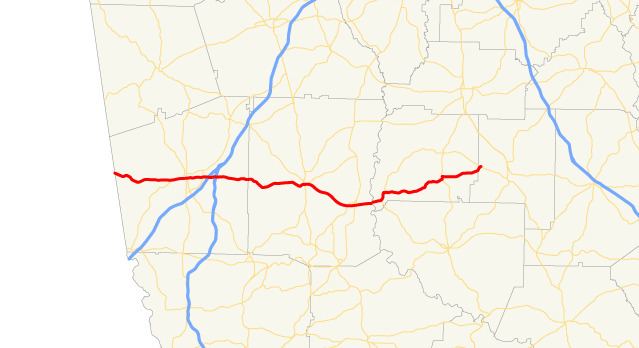 | ||
West end: CR 20 at the Alabama state line west of Glenn, Georgia East end: SR 18 between Zebulon and Barnesville Counties Heard County, Georgia, Troup County, Georgia | ||
State Route 109 (SR 109) is a 71.0-mile-long (114.3 km) state highway that runs west-to-east through portions of Heard, Troup, Meriwether, Pike, and Lamar counties in the western part of the U.S. state of Georgia.
Contents
- Map of GA 109 Georgia USA
- Route description
- Troup County spur route
- Meriwether County spur route
- References
Map of GA-109, Georgia, USA
Route description
SR 109 begins at the Alabama state line, where the roadway continues as CR 20, west of Glenn. The road heads eastward, until it enters town. Then, it heads southeast into Troup County. Farther in the county, it meets the eastern terminus of SR 109 Spur (Roanoke Road). At this intersection, the highway turns left to cross over West Point Lake. It enters LaGrange and intersects US 29/SR 14. In the main part of town, the three routes meet US 27/SR 1/SR 219. At this intersection US 29/SR 14 depart to the north, along US 27/SR 1/SR 219 north. On the east end of town, it has an interchange with Interstate 85 (I-85). Then, it crosses over, but does not interchange with I-185. In Greenville, the highway meets US 27 Alternate/SR 18/SR 41, as well as SR 100 (North Depot Street). Here, US 27 Alternate/SR 18/SR 41/SR 109 run concurrent around the city square. SR 18 runs concurrent with SR 109 to the east. Just before leaving town, they intersect SR 109 Spur (Gay Road). In Woodbury, is an intersection with SR 85 Alternate (Whitehouse Parkway). Then, they meet SR 74/SR 85. At this intersection, SR 74 joins the concurrency. Just before entering Molena, SR splits off on Crest Highway. In town, SR 18 splits off to the north-northeast, while SR 109 heads east. The road heads northeast to a concurrency with US 19/SR 3, just west-southwest of Meansville. SR 109 heads through town and meets its eastern terminus, an intersection with SR 18, located between Zebulon and Barnesville.
SR 109 is not part of the National Highway System, a system of roadways important to the nation's economy, defense, and mobility.
Troup County spur route
State Route 109 Spur (SR 109 Spur) is a spur route that exists entirely within the west-central part of Troup County. It used to be part of the SR 109 mainline and is known as Roanoke Road for its entire length.
It begins at the Alabama state line, where the roadway continues as CR 278. The road crosses over an arm of West Point Lake. It then passes the Harmony Cemetery, before it meets its eastern terminus, an intersection with the SR 109 mainline, west of LaGrange.
SR 109 Spur is not part of the National Highway System, a system of roadways important to the nation's economy, defense, and mobility.
The entire route is in Troup County.
Meriwether County spur route
State Route 109 Spur (SR 109) is a spur route that connects SR 18/SR 109 (Woodbury Road) in Greenville to SR 74/SR 85 (Oakland Road) in Gay. It is located in the central and east-central parts of Meriwether County.
This road was designated because of the long distance on SR 74/SR 85 connecting Gay and SR 18/SR 109 in Woodbury. This also helps smooth traffic going to the Cotton Pickin' Fair in Gay.
The entire route is in Meriwether County.