
 | ||
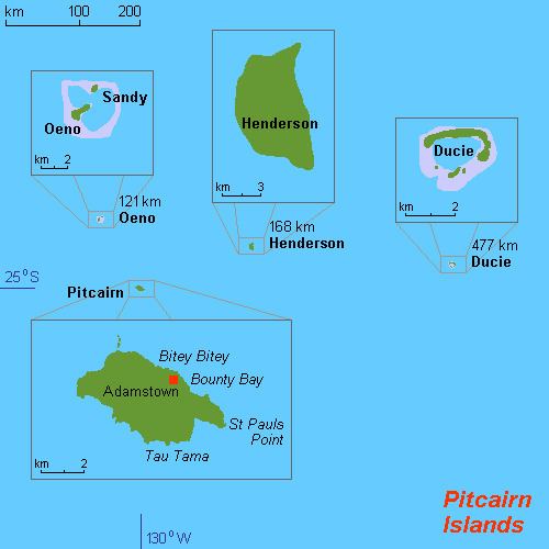
The Pitcairn Islands consist of four islands: Pitcairn Island, Oeno Island, Henderson Island and Ducie Island:
Contents
- Location
- Area
- Area comparative
- Land boundaries
- Coastline
- Maritime claims
- Climate
- Terrain
- Elevation extremes
- Natural hazards
- Environment current issues
- Maps
- References
Pitcairn Islands as a group of islands (25°04′00″S 130°05′00″W)
Pitcairn Island is a volcanic high island. Henderson Island is an uplifted coral island. Ducie and Oeno are coral atolls.
The only inhabited island, Pitcairn, has an area of 5 km2 (1.9 sq mi) and a population density of 10/km²; it is only accessible by boat through Bounty Bay.
The other islands are at a distance of more than 100 km (62 mi). Wikimedia Atlas of the Pitcairn Islands
Location
Oceania, islands in the South Pacific Ocean, about one-half of the way from Peru to New Zealand, one of the most remote sites of human habitation on Earth.
The inhabited island, Pitcairn, is at 25.04 south, 130.06 west. Pitcairn is about 2,170 kilometres (1,350 mi) southeast of Tahiti, 5,310 kilometres (3,300 mi) from Auckland, New Zealand, and over 6,600 kilometres (4,100 mi) from Panama.
Area
Total: 47 km²
Land: 47 km²
Water: 0 km²
Pitcairn Island is about 3.2 kilometres (2.0 mi) long and 1.6 kilometres (0.99 mi) wide.
Area - comparative
About 0.3 times the size of Washington, DC
Land boundaries
0 km
Coastline
51 km
Maritime claims
Exclusive economic zone: 836,000 sq kilometres
Territorial sea: 3 nmi
Climate
Tropical, hot, humid; modified by southeast trade winds; rainy season (November to March)
Terrain
Rugged volcanic formation; rocky coastline with cliffs
Elevation extremes
Lowest point: Pacific Ocean 0 m
Highest point: Pawala Valley Ridge 347 m (1,138 ft)
Natural hazards
Typhoons (especially November to March)
Environment - current issues
Deforestation (only a small portion of the original forest remains because of burning and clearing for settlement)
Maps
Worldwide map services show very little detail of the islands, and are even of limited use to show the location of them with respect to each other and to other islands, because they are so small and far apart. However, Mapquest zoom level 1 is a suitable map to see the location between Peru and New Zealand.
For the location with respect to French Polynesia, see the inset of Image:French Polynesia map.jpg.