
Location Western Europe Coastline 160 km (99 mi) Highest point Snaefell Elevation 621 m Peak Snaefell Adjacent body of water Irish Sea | Adjacent bodies of water Irish Sea Highest elevation 621 m (2,037 ft) Largest town Douglas (pop. 23,000) Area 572 km² Archipelago British Isles | |
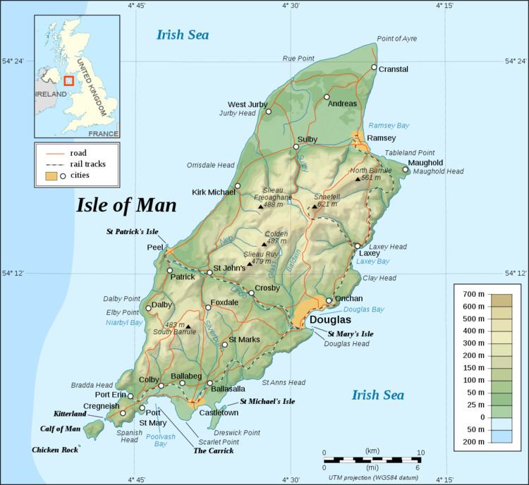 | ||
The Isle of Man is an island in the Irish Sea, between Great Britain and Ireland in Western Europe, with a population of almost 85,000. It is a British Crown dependency. It has a small islet, the Calf of Man, to its south. It is located at 54°15′N 4°30′W.
Contents
- Map of Isle of Man
- DimensionsEdit
- Coast and Territorial SeaEdit
- ClimateEdit
- TerrainEdit
- Land useEdit
- Natural hazards and environmental issuesEdit
- Protected sites for nature conservationEdit
- UNESCO Biosphere ReservesEdit
- Ramsar sitesEdit
- National nature reservesEdit
- Areas of Special Scientific ImportanceEdit
- Marine nature reservesEdit
- Areas of Special ProtectionEdit
- Bird sanctuariesEdit
- Nature reserves and wildlife sitesEdit
- Marine no take zonesEdit
- GeologyEdit
- DemographicsEdit
- References
Map of Isle of Man
DimensionsEdit
Area:
total: 572 km2 (221 sq mi)
land: 571 km2 (220 sq mi)
water: 1 km2 (0.4 sq mi)
This makes it:
Coast and Territorial SeaEdit
The Isle of Man has a coastline of 160 km (99 mi), and a territorial sea extending to a maximum of 12 nm from the coast, or the midpoint between other countries. The total territorial sea area is about 4000 km2 or 1500 sq miles, which is about 87% of the total jurisdiction of the Isle of Man. The Isle of Man only holds exclusive fishing rights in the first 3 nm. The territorial sea is managed by the Isle of Man Government Department of Infrastructure.
The Raad ny Foillan long distance footpath runs 153 km (95 mi) around the Manx coast.
ClimateEdit
The Isle of Man enjoys a temperate climate, with cool summers and mild winters. Average rainfall is high compared to the majority of the British Isles, due to its location to the western side of Great Britain and sufficient distance from Ireland for moisture to be accumulated by the prevailing south-westerly winds. Average rainfall is highest at Snaefell, where it is around 1,900 mm (74.8 in) a year. At lower levels it can fall to around 800 mm (31.5 in) a year.
Temperatures remain fairly cool, with the recorded maximum being 28.9 °C (84.0 °F) at Ronaldsway.
TerrainEdit
The island's terrain is varied. There are two mountainous areas divided by a central valley which runs between Douglas and Peel. The highest point in the Isle of Man, Snaefell, is in the northern area and reaches 620 metres (2,034 ft) above sea level. The northern end of the island is a flat plain, consisting of glacial tills and marine sediments. To the south the island is more hilly, with distinct valleys. There is no land below sea level.
Land useEdit
Natural hazards and environmental issuesEdit
There are few severe natural hazards, the most common being high winds, rough seas and dense fog. In recent years there has been a marked increase in the frequency of high winds, heavy rains, summer droughts and flooding both from heavy rain and from high seas. Snow fall has decreased significantly over the past century while temperatures are increasing year round with rainfall decreasing.
Air pollution, marine pollution and waste disposal are issues in the Isle of Man.
Global warming and a sea level rise potentially pose a great threat to the Isle of Man. All of the Island's towns are at threat from rising sea levels while the Northern Plain, a large, flat and low-lying plain composed of soft marine sediments and glacial material, which makes up about a quarter of the Island's landmass, is in danger of being lost to the sea over the next two centuries. The same is true for the considerably smaller Southern Plain surrounding the settlements of Castletown and Ballasalla and including Ronaldsway Airport[1].
Protected sites for nature conservationEdit
In order of importance, international first, non-statutory last.
UNESCO Biosphere ReservesEdit
Ramsar sitesEdit
National nature reservesEdit
Areas of Special Scientific ImportanceEdit
There are 21 ASSIs on the Isle of Man as of 01/09/16. One additional ASSI has been rescinded (Ramsey Harbour).
Marine nature reservesEdit
A marine nature reserve was designated in Ramsey Bay in Oct 2011.
Areas of Special ProtectionEdit
Bird sanctuariesEdit
Nature reserves and wildlife sitesEdit
The Isle of Man now has forty-five non-statutory wildlife sites as of 30 January 2009, covering approximately 195ha of land and an additional 10.5 km (6.5 mi) of inter-tidal coast. The Manx Wildlife Trust also manage twenty four nature reserves, along with the Calf of Man as of September 2016:
Marine no-take zonesEdit
GeologyEdit
The larger part of the island is formed from highly faulted and folded sedimentary rocks of Ordovician age. There is a belt of younger Silurian rocks along the west coast between Niarbyl and St Patrick's Isle and a small area of Devonian sandstones around Peel. A band of Carboniferous age rocks underlies part of the northern plain but is nowhere seen at the surface however similar age rocks do outcrop in the south between Castletown, Silverdale and Port St Mary. Permo-Triassic age rocks are known to lie beneath Point of Ayre but, as with the rest of the northern plain, these rocks are concealed by substantial thicknesses of superficial deposits.
The island has significant deposits of copper, lead and silver, zinc, iron, and plumbago (a mix of graphite and clay). There are also quarries of black marble, limestone flags, clay schist, and granite. These are all modern, and there was no noticeable exploitation of metals or minerals prior to the modern era.
DemographicsEdit
The island has a census-estimated population of 84,497 according to the most recent 2011 census: up from 79,805 in 2006 and 76,315 in 2001.
The island's largest town and administrative centre is Douglas, whose population is 23,000 — nearly a third of the population of the island. Neighbouring Onchan, Ramsey in the north, Peel in the west and the three southern ports of Castletown, Port Erin and Port St Mary are the island's other main settlements. Almost all its population lives on or very near the coast.