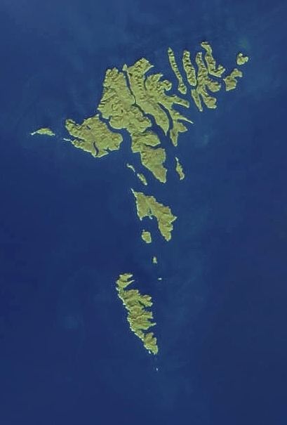
The Faroe Islands are an island group consisting of eighteen islands between the Norwegian Sea and the North Atlantic, about half-way between Iceland and Norway. Its coordinates are 62°N 7°W. It is 1,393 square kilometres in area, and includes small lakes and rivers, but no major ones. There are 1,117 kilometres of coastline, and no land boundaries with any other country.
The Faroe Islands generally have cool summers and mild winters, with a usually overcast sky and frequent fog and strong winds. Although at a high latitude, due to the Gulf Stream their climate is ameliorated. The islands are rugged and rocky with some low peaks; the coasts are mostly bordered by cliffs. The Faroe Islands are notable for having the highest sea cliffs in Europe, and some of the highest in the world otherwise. The lowest point is at sea level, and the highest is at Slættaratindur, which is 882 metres above sea level. The landscape made roadbuilding difficult, and only recently has this been remedied by building tunnels.
Many of the Faroese islands tend to be elongated in shape. Natural resources include fish and hydropower.
Geographic coordinates62°00′N 06°47′WNorth: Enniberg, 62°29′,2 NSouth: Sumbiarsteinur, 61°21′,6 NWest: Gáadrangur, 7°40′,1 WEast: Stapin, 6°21′,5 WAreaLand: 1,393 km² Water: 7.19 km² (the area includes 10 of the largest lakes. There are a number of smaller lakes and streams.)Land boundaries0 km
Coastline1,117 km
Maritime claimsTerritorial sea: 3 nmi (5.6 km; 3.5 mi)Continental shelf: 200 nmi (370.4 km; 230.2 mi) or agreed boundaries or median lineExclusive economic zone: 200 nmi (370.4 km; 230.2 mi) or agreed boundaries or median lineClimateSubarctic
oceanic climate (
Köppen climate classification Cfc) moderated by
North Atlantic Current; long, mild, windy winters; short, cool summers, damp in the South and West. Arctic climate (Köppen
ET) in some mountains.
TerrainRugged, rocky, some low peaks; cliffs along most of coast. The coasts are deeply indented with
fjords, and the narrow passages between islands are agitated by strong tidal currents.
Elevation extremesLowest point: Atlantic Ocean 0 mHighest point: Slættaratindur 880 mNatural resourcesFish, whales,
hydropower,
wind, possible
petroleum and gas
Land useArable land: 2.14%Permanent crops: 0%Other: 97.86% (2012)Environment—international agreementsMarine dumping