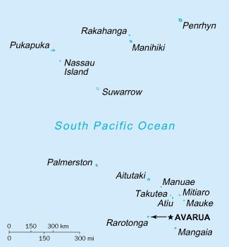
The Cook Islands can be divided into two groups: the Southern Cook Islands and the Northern Cook Islands.
Southern Cook Islands
Aitutaki
Atiu
Mangaia
Manuae
Mauke
Mitiaro
Palmerston Island
Rarotonga (capital)
Takutea
Northern Cook Islands
Manihiki
Nassau
Penrhyn Island
Pukapuka
Rakahanga
Suwarrow
Oceania, group of islands in the South Pacific Ocean, about one-half of the way from Hawaii to New Zealand
Geographic coordinates
21°14′S 159°46′W
Map references
Oceania
Area
Total: 236 km2 (91 sq mi)
Land: 236 km2
Water: 0 km2
Area - comparative
1.3 times the size of Washington, DC
Land boundaries
0 km
Coastline
120 km (75 mi)
Maritime claims
Territorial sea: 12 nmi (22.2 km; 13.8 mi)
Continental shelf: 200 nmi (370.4 km; 230.2 mi) or to the edge of the continental margin
Exclusive economic zone: 200 nmi (370.4 km; 230.2 mi)
Climate
Tropical; moderated by trade winds; a dry season from April to November and a more humid season from December to March
Terrain
Low coral atolls in north; volcanic, hilly islands in south
Elevation extremes
Lowest point: Pacific Ocean 0 m
Highest point: Te Manga 652 m (2,139 ft)
Natural resources
coconuts
Land use
Arable land: 4.17%
Permanent crops: 4.17%
Other: 91.67% (2012 est.)
Irrigated land
NA
Natural hazards
Typhoons (November to March)
Environment - current issues
NA
Environment - international agreements
Party to: Biodiversity, Climate Change, Climate Change-Kyoto Protocol, Desertification, Hazardous Wastes, Law of the Sea, Ozone Layer Protection
Signed, but not ratified: none