
Location Gulf of Saint Lawrence Population 139,407 (2008) | Highest elevation 152 m (499 ft) Elevation 152 m | |
 | ||
Area 5,683.91 km (2,194.57 sq mi) Pop. density 24.53 /km (63.53 /sq mi) | ||
Prince Edward Island's geography is mostly pastoral with red soil, white sand, and scattered communities. Known as the "Garden of the Gulf", the island is located in the Gulf of Saint Lawrence north of Nova Scotia and east of New Brunswick, with which it forms the Northumberland Strait.
Contents
Map of Prince Edward Island, Canada
PEI consists of the capital city Charlottetown, as well as urban towns Cornwall and Stratford and a developing urban fringe. A smaller urban area surrounds Summerside Harbor, situated on the southern shore 40 kilometers west of Charlottetown Harbor, and consists primarily of the city of Summerside. As with all natural harbors on the island, Charlottetown and Summerside harbors are created by rias. (See also a list of communities in Prince Edward Island.)
The island's landscape is pastoral: rolling hills, pristine forests, white sand beaches, ocean coves and the famous red soil have given Prince Edward Island a reputation as a province of outstanding natural beauty. A number of laws have been passed by the provincial government to attempt to preserve the landscape through regulation, although the lack of consistent enforcement and absence of province-wide zoning and land-use planning has resulted in some aesthetically displeasing development in recent years.
The island's lush landscape has had a strong bearing not only on its economy but also its culture. Author Lucy Maud Montgomery drew inspiration from the land during the late Victorian Era for the setting of her classic novel Anne of Green Gables. Today, many of the same qualities that Montgomery and others found in the Island are enjoyed by tourists who visit during all seasons. They enjoy a variety of leisure activities, including beaches, various golf courses, eco-tourism adventures, and simply touring the countryside and enjoying cultural events in local communities around the island.
The highest point of land is located at Springton in Queens County (152 metres or 499 feet above sea level).
Communities
The smaller rural communities as well as the towns and villages throughout the province proudly retain a slower-paced, old world flavor, something that factors heavily into Prince Edward Island's popularity as a destination for relaxation. Most rural communities on Prince Edward Island are based on small-scale agriculture, given that the size of farm properties is quite small when compared with other areas in Canada. There is an increasing amount of industrial farming as older farm properties are consolidated and modernized.
Coastline
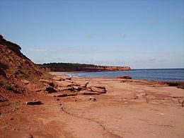
The coastline of the island consists of a combination of long beaches, dunes, red sandstone cliffs, salt water marshes and numerous bays and harbours. The beaches, dunes and sandstone cliffs consist of sedimentary rock and other material with a high iron concentration which oxidizes upon exposure to the air. The geological properties of a white silica sand found at Basin Head are unique in the province; the sand grains cause a scrubbing noise as they rub against each other when walked on. Large dune fields on the north shore can be found on barrier islands at the entrances to various bays and harbours. The magnificent sand dunes at Greenwich are of particular significance. The shifting, parabolic dune system is home to a variety of birds and rare plants and is also a site of significant archeological interest.