
 | ||
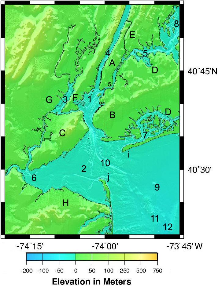
The system of waterways of the Port of New York and New Jersey forms one of the most intricate natural harbors in the world. Although the overall form of the estuary remains unchanged from the time of Giovanni da Verrazzano's visit in 1524, no part of it remains unaffected by human activity, and some parts, such as Hell Gate and Ellis Island have been almost completely altered. In the greatest hidden change, the navigational channels have been deepened from the natural 17 feet depth to 45 feet, in some places requiring blasting of bedrock. The harbor lies at the confluence of three major bodies of water. The harbor opens onto the New York Bight (Atlantic Ocean) to the southeast and Long Island Sound to the northeast. Both of these are essentially marine bodies with both tides and saltwater, but the Sound compared to the Atlantic is about 20-30% less saline (as an estuary), and the tide is about 3 hours later with as much as 70% more variation. The Hudson River adds a fresher, non-tidal inflow from the north, although the tide and brackishness extend well up river.
Contents
- Features of the harbor
- Rivers and streams
- Tidal straits
- Bays inlets and coves
- Bi state
- New Jersey
- Land features
- Port facilities
- Lights and lighthouses
- Government and other agencies
- State county municipal
- References
These three combine to generate an extremely complex system of tides and currents throughout the extended hydrologic system from Albany to Montauk Point to the Hudson Canyon region of the New York Bight. The New York Harbor Observing and Prediction System (NYHOPS) utilizes information from sensors, weather forecasts, and environment models to provide real-time forecasts of meteorological and oceanographic conditions in the area.
Features of the harbor
The lists below includes features of Port of New York and New Jersey with a waterborne emphasis starting with natural features. Where possible the list proceeds from Lower Bay entrance approximately clockwise around Harbor. The alternative sorting is by jurisdiction.
Official references are the NOAA Coastal pilot, NOAA nautical charts, and USGS topographic maps. Many jurisdictional issues appear in U.S. law.
Rivers and streams
Bi-state
New Jersey
New York
Tidal straits
Inter-state
New York
Bays, inlets and coves
Lower New York Bay
Upper New York Bay
East River
Long Island Sound
Bi-state
New Jersey
Land features
New Jersey
New York
Port facilities
One of the many duties of the Port Authority of New York and New Jersey is to develop trade interests in the New York-New Jersey area. The PA operates most of the containerized port facilities listed here, and also collaborates with the Army Corps of Engineers to maintain shipping channels in the harbor.
New Jersey numerous privately operated bulk facilities, especially petroleum, not listed
New York
Lights and lighthouses
For lists see and. Active unless noted.
New Jersey
New York
Government and other agencies
State, county, municipal
New Jersey
New York