
Location Caribbean Sea Highest elevation 1,397 m (4,583 ft) Overseas department Martinique Area 1,060 km² Archipelago Windward Islands | Coastline 350 km (217 mi) Highest point Montagne Pelee Elevation 1,397 m Peak Mount Pelée | |
 | ||
Largest settlement Fort-de-France (pop. 134,727) | ||
Climate
Martinique has a warm, stable climate that only varies 5 degrees Fahrenheit all year round. Trade winds blow refreshing breezes from the northeast.
Contents
Statistics
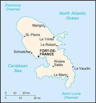
Location: Caribbean, island in the Caribbean Sea, southeast of Puerto Rico and north of Trinidad and Tobago
Geographic coordinates: 14°40′N 61°00′W
Map references: Central America and the Caribbean
Area:
total: 1,100 km²
land: 1,060 km²
water: 40 km²
Area - comparative: slightly more than six times the size of Washington, D.C.
Land boundaries: 0 km
Coastline: 350 km
Maritime claims:
exclusive economic zone: 200 nmi (370.4 km; 230.2 mi)
territorial sea: 12 nmi (22.2 km; 13.8 mi)
Climate: tropical; moderated by trade winds; rainy season (June to October); vulnerable to devastating cyclones (hurricanes) every eight years on average; average temperature 17.3 degrees Celsius; humid
Terrain: mountainous with indented coastline; dormant volcano
Elevation extremes:
lowest point: Caribbean Sea 0 m
highest point: Montagne Pelee 1,397 m
Natural resources: coastal scenery and beaches, cultivable land
Land use:
arable land: 8%
permanent crops: 8%
permanent pastures: 17%
forests and woodland: 44%
other: 23% (1993 est.)
Irrigated land: 40 km² (1993 est.)
Natural hazards: hurricanes, flooding, and volcanic activity (an average of one major natural disaster every five years)
Environment - current issues: NA
Population:429,510