
 | ||
Geography of malta
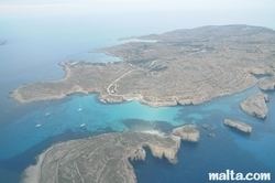
The geography of Malta is dominated by water. Malta is an archipelago of coralline limestone, located in the Mediterranean Sea, approximately 93 kilometres south of Sicily, Italy, and nearly 300 km north (Libya) and northeast (Tunisia) of Africa. Although Malta is situated in Southern Europe, it is located farther south than African Tunis, capital of Tunisia, Algiers, capital of Algeria, Tangier in Morocco and also Aleppo in Syria, and Mosul in Iraq in the Middle East. Only the three largest islands – Malta, Gozo and Comino – are inhabited. Other (uninhabited) islands are: Cominotto, Filfla and the St.Paul's Islands. The country is approximately 316 km2 (122 sq mi) in area. Numerous bays along the indented coastline of the islands provide good harbours. The landscape of the islands is characterised by high hills with terraced fields. The highest point, at 253 metres, Ta' Zuta on mainland Malta. The capital is Valletta.
Contents
- Geography of malta
- Statistics
- Climate
- Elevation extremes
- Land use
- Irrigated land
- Total renewable water resources
- Current issues
- International Agreements
- References
Geographic coordinates: 35°50′N 14°35′E
Statistics
Map references: Europe
Area:
Area - comparative: slightly less than twice the size of Washington, DC
Land boundaries: 0 km
Coastline: 196.8 km (excludes the 56 km for the island of Gozo)
Maritime claims:
Climate
Mediterranean with mild, rainy winters and hot, dry summers.
Elevation extremes
Ta' Dmejrek 253 m
Land use
Irrigated land
32 km2 (2007)
Total renewable water resources
0.05 km3 (2011)
Current issues
Limited natural fresh water resources; increasing reliance on desalination.
International Agreements
signed, but not ratified: