
 | ||
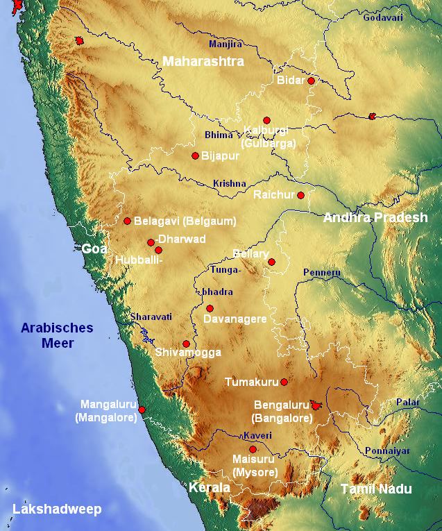
The Indian State of Karnataka is located 11°30' North and 18°30' North latitudes and 74° East and 78°30' East longitude. It is situated on a tableland where the Western and Eastern Ghat ranges converge into the complex, in the western part of the Deccan Peninsular region of India. The State is bounded by Maharashtra and Goa States in the north and northwest; by the Arabian Sea in the west; by Kerala and Tamil Nadu States in the south and by the States of Andhra Pradesh and Telangana in the east. Karnataka extends to about 750 km from north to south and about 400 km from east to west.
Contents
Karnataka is situated in the Deccan Plateau and is bordered by the Arabian Sea to the west, Goa to the northwest, Maharashtra to the north, Andhra Pradesh and Telangana to the east, Tamil Nadu to the southeast, and Kerala to the southwest. It is situated at the angle where the Western Ghats and Eastern Ghats of South India converge into the Nilgiri hills. The highest point in Karnataka is the Mullayanagiri hill in Chikkamagaluru district which has an altitude of 1,929 metres (6,329 ft) above sea level.
Landforms of Karnataka
The state has three principal physical zones;
Karnataka has one of the highest average elevations of Indian states at 1,500 feet. The highest recorded temperature was 45.6 °C (114.08 °F) at Raichur on May 23, 1928. The lowest recorded temperature was 2.8 °C (37.04 °F) at Bidar on December 16, 1918.
Area and population
Karnataka has a total land area of 1,91,791 km² and accounts for 5.83% of the total area of the country (measured at 3,288,000 km²). This puts it in seventh place in terms of size. With a population of 6,11,30,704, it occupies eighth place in terms of population. The population density which stands at 319 persons per km² is lower than the all-India average of 382.
Geology
According to Radhakrishnan and Vaidyanadhan (1997), there are four main types of geological formations in Karnataka:
Soil types
Eleven groups of soil orders are found in Karnataka viz. Entisols, Inceptisols, Mollisols, Spodosols, Alfisols, Ultisols, Oxisols, Aridisols, Vertisols, Andisols and Histosols. Depending on the agricultural capability of the soil, the soil types are divided into six types viz., Red, lateritic (lateritic soil is found in bidar and kolar district), black, alluvio-colluvial, forest and coastal soils. The common types of soil groups found in Karnataka are:
Climate
Karnataka has the following four seasons in the year:
The post-monsoon (period of retreating) and winter seasons are generally pleasant over the entire state. The months April and May are hot, very dry and generally uncomfortable. Weather tends to be oppressive during June due to high humidity and temperature. The next three months (July, August and September) are somewhat comfortable due to reduced day temperature although the humidity continue to be very high. The highest recorded temperature was 45.6 °C (114 °F) at Raichur on May 23, 1928. The lowest recorded temperature was 2.8 °C (37 °F) C at Bidar on December 16, 1918.
Karnataka is divided into three meteorological zones:
Rainfall
The southwest monsoon accounts for almost 80% of the rainfall that the state receives. The annual rainfall across the state ranges from low 50 cm to copious 350 cm. The districts of Bijapur, Raichur, Bellary and Southern half of Gulbarga experience the lowest rainfall ranging from 50 to 60 cm while the west coastal region and Malenadu enjoy the highest rainfall. Agumbe in the Western Ghats experiences the heaviest rainfall in the country next only to Cherrapunji.
Forests
About 38724 km² (or 20% of Karnataka's geographic) are covered by forests. The forests are classified as reserved (28.611 km²) protected (3,932 km²), unclosed (5,748 km²), village (124 km²) and private (309 km²) forests. The percentage of forests area to Geographical area in the State is less than the all-India average of about 23%, and 33% prescribed in the National Forest Policy. The area under protected forests in the neighboring States is as follows: Andhra Pradesh 62,000 km² (9% of the total area of the country), Maharashtra 54,000 km² (8%), Tamil Nadu 22,000 km² (3%) and Kerala 11,000 km² (2%).
Karnataka is known for its valuable timbers from the evergreen forests in the Western Ghat region, notably Teak and Rosewood, the richly ornate panels of which adorn the beautiful chambers of the Two Houses of Karnataka Legislature.