
 | ||
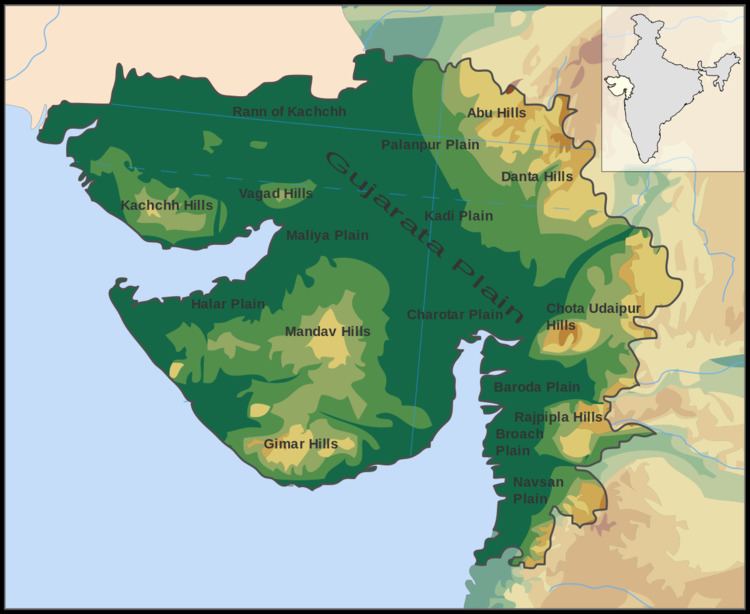
Ranges
Hill
Rivers
Ecoregions
According to the WWF, Gujarat covers portions of five terrestrial ecoregions:
Contents
Beaches
Ahmedpur Mandvi Beach - Ahmedpur Mandvi Beach is situated on the coastline of the state of Gujarat and is one of the finest beaches in India. It is located in Ahmedpur Mandvi,located near Union Territory Diu.
Mandvi Beach - Kutch - Mandvi Wind Farms Beach and Wind-mills, which line the horizon of Mandvi, offer a spectacular view from the Mandvi sea-beach. The Wind mills projects running in this beach was Asia's 1st Wind-Mills Projects in 1983.
Chorwad Beach - Chorwad Beach of Gujarat is another splendid beach situated on the west coast of India. It is situated at a distance of 66 km from Junagadh. Chorwad has a high potential of attracting both domestic as well as international tourists. The beach consists of rocky hills and presents an opportunity for thrilling boat rides.
Diu Beach - Diu beach is situated off the Saurashtra coast and is connected to the state of Gujarat via a causeway. Diu is a secluded island and does not have much population. This makes it an ideal place for a serene vacation, away from the worries of daily life.
Gopnath Beach - Gopnath Beach is situated in the Bhavnagar district of Gujarat. It comes into Talaja Taluka. It is located on the coast of the Gulf of Kambhat, at a distance of 75 km from the city of Bhavnagar. and 22 km. away from Talaja. Gopnath is a pristine beach known for its natural beauty. The Fort of the King of Gohilvad is situated in Gopnath.
Kutch Mandvi Beach — Kutch Mandvi is an important beach in Gujarat, situated at Mandvi. Mandvi is the historic port town of Maharao of Kutch, located at a distance of 75 km from Bhuj. Kutch Mandvi was once inhabited by the Maharao of Kutch and was an important seaport.
Umbergam Beach - Umargam is about 6 km from Umargam Road railway station on Mumbai-Surat rail section . This region was a part of Thane district prior to the creation of Gujarat in 1960.
Umargam is situated on the southern bank of Nargol creek. It was a small village about two centuries ago, serving as a transit point for exporting marine produce from the fishing port Nargol on the Northern Bank of the creek.
Tithal Beach (Valsad) Tithal beach 5 km from Valsad.