
 | ||
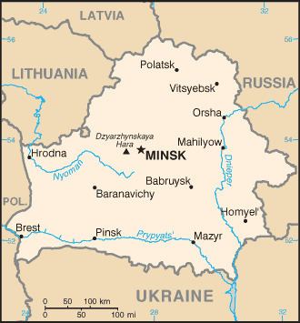
Belarus, a landlocked, generally flat country (the average elevation is 162 meters (531 ft) above sea level) without natural borders, occupies an area of 207,600 square kilometers (80,200 sq mi), or slightly smaller than the United Kingdom or the state of Kansas. Its neighbors are Russia to the east and northeast, Latvia to the north, Lithuania to the northwest, Poland to the west, and Ukraine to the south. Its extension from north to south is 560 km (350 mi), from west to east is 650 km (400 mi).
Contents
Topography and drainage
Belarus's level terrain is broken up by the Belarusian Range (Byelaruskaya Hrada), a swathe of elevated territory of individual highlands, that runs diagonally through the country from west-southwest to east-northeast. Its highest point is the 346-meter (1,135 ft) Mount Dzyarzhynskaya, named for Felix Dzerzhinsky, head of Cheka. Northern Belarus has hilly landscape with many lakes and gently sloping ridges created by glacial debris. In the south, about one-third of the republic's territory around the Pripiac River is taken up by the low-lying swampy plain of Palyessye, shared with Ukraine, Poland and Russia.
Belarus's 3,000 streams and 4,000 lakes are major features of the landscape and are used for floating timber, shipping, and power generation. Major rivers are the west-flowing Western Dvina and Nyoman rivers, and the south-flowing Dniapro River with its tributaries, the Berezina, Sozh, and Prypyat rivers. The Prypyat River has served as a bridge between the Dnepr, flowing to Ukraine and the Vistula in Poland since the period of Kievan Rus'.
Glacial scouring accounts for the flatness of Belarusian terrain and for its numerous lakes. Lake Narach, the country's largest lake, covers 79.6 square kilometers. Other big lakes are Osveya (52.8 km2), Chervonoye (43.8 km2), Lukomlskoye (36.7 km2) and Dryvyaty (36.1 km2). Lake Drysvyaty (Drūkšiai) (44.8 km2) is situated on the border of Belarus and Lithuania. The deepest lake in Belarus is Doŭhaje (53.7 m). Chervonoye is the most shallow among the large lakes, with a maximum depth of 4 m. The majority of large lakes are situated in Northern Belarus. In Braslaw and Ušačy districts, lakes cover more than 10% of their territory.
Nearly one-third of the country is covered with pushchas, large unpopulated tracts of forests. Share of area covered with forests ranges from 34% in the Brest and Hrodna regions to 45% in the Homiel region. Forests cover 36–37.5% of the Minsk, Mahilioŭ and Vitsebsk regions. Districts with the highest percentage of area covered by forests are Rasony and Lielčycy, in the extreme northern and southern parts of Belarus respectively. Level of woodiness had declined during history – from 60% in 1600 AD to 22% in 1922, but started to increase in the middle of the 20th century. The Belavezhskaya Pushcha (shared with Poland) in the far west is the oldest and most magnificent of the forests; a reservation here shelters animals and birds that became extinct elsewhere in the distant past.
Climate
Because of the proximity of the Baltic Sea (257 kilometers or 160 miles at the closest point), the country has a temperate continental climate. Winters last between 105 and 145 days, and summers last up to 150 days. The average temperature in January is −6 °C (21 °F), and the average temperature for July is about 18 °C (64 °F), with high humidity. Average temperature for July ranges from 17.5 °C (64 °F) in the north, 18.5–19 °C (66 °F) in the south. For January, it ranges from −4.5 °C (24 °F) in the southwest to −8 °C (18 °F) in the northeast. Average annual precipitation ranges from 550 to 700 millimeters (21.7 to 27.6 in) and is sometimes excessive.
The highest average yearly precipitation is recorded in Navahrudak (769 mm per year). The highest yearly precipitation ever recorded was in Vasilievičy (1,115 mm per year), the lowest – in Brahin (298 mm). 70% of precipitation falls from April to October. Heavy rains are common in summer. Sometimes one-day precipitation during summer rainfall exceeds average monthly precipitation. The heaviest rain ever was recorded in July 1973 in Slaŭnaje in Talachyn Raion – 148 mm in one day. The highest humidity level is observed in December and January (90%), the lowest – in May and June (65–70%) with an average level of 80%. Days with humidity lower than 30% are rare – usually less than 20 every year, with only 3–5 such days in some regions. On the contrary, there are more than 100 days with high humidity (over 80%), in some regions – up to 152. Due to high humidity, areas around Minsk and Navahrudak have from 65 to 100 foggy days every year.
Flora and Fauna
In Belarus, nearly 1,500 species of vascular plants (including 1,422 flowering plants), 450 mosses, 2,000 algae and 1,500 fungus species are known. In the north, conifers predominate in forests that also include birch and alder; farther south, other deciduous trees grow. Pines compose 50.2% of total forest area, spruces – 10%, black alder – 8.2%, oaks – 3.3%, gray alder – 2.3%, aspen – 2.1%. 15.4% of Belarus is covered by meadows with one third being natural and the rest being specially cultivated. The most common plants on natural meadows are Deschampsia and several different sedges (Carex). In the marshes, 267 species of Embryophyta are growing – herbs (167 species), trees and bushes (37 species), Bryidae (32 species) and Sphagnopsida (31 species). 50 of them are considered drug plants.
Animals in Belarus are those common to Central and Eastern Europe.
National Parks
The National Parks are a huge part of the country's identity. The people of Belarus are particularly proud of their country's national parks. Believezhskaya Puscha National Park was listed on the World Heritage Sites by Unesco in 1992. Later, the Council of Europe stated that the park was one of the most conservation conscious areas. Many animals can be found in these parks, i.e., red dear, wild boar and elk.
Environmental concerns
Chernobyl Disaster
The most notorious legacy of pollution from the Soviet era is the Chernobyl Disaster of 1986. It has been estimated that 70% of the atmospheric radiation was blown into Belarus from Ukraine causing health issues for approximately 25% of its population; Homyel and Mahilyow are some of the most highly affected Providences. Two million people (including 600,000 children), whom lived in areas that were heavily affected by the radiation, claimed to have serious issues after the event. Swedish scientists pressured The Soviet government, who tried to cover up the accident, to explain why there were higher levels of radiation now in Sweden.
The Belarusian government's request to the Soviet government for a minimum of 17 billion roubles to deal with the consequences was answered with Moscow's offer of only 3 billion roubles. According to one official in 1993, the per capita expenditure on the accident was one kopeck in Russia, three kopecks in Ukraine, and one rouble (100 kopecks) in Belarus.
Despite the government's establishment of the State Committee for Chernobyl, the enactment of laws limiting who may stay in contaminated areas, and the institution of a national program for research on the effects, little progress was made in coping with the consequences of the disaster, owing to the lack of money and the government's sluggish attitude. In 1994, a resettlement program for 170,000 residents was woefully underbudgeted and far behind schedule. To assist victims of Chernobyl, a Western organization called the Know-How Fund provided many Belarusian doctors with training in the latest bone-marrow techniques of Europe and the United States.
The long-range effects of the disaster include an increasing incidence of various kinds of cancer and birth defects; congenital defects in newborns are reported to be 40% higher than before the accident. Tainted water, livestock, farm produce, and land are widespread, and the extensive wetlands retain high concentrations of radiation. Cleanup of the disaster accounted for 14% of the state budget in 1995. Other environmental problems include widespread chemical pollution of the soil, which shows excessive pesticide levels, and the industrial pollution present near most of the large cities.