
 | ||
This article describes the geography of Anguilla.
Contents
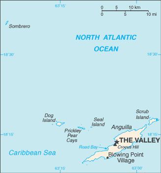
Anguilla is an island in the Leeward Islands, which lies between the Caribbean Sea in the west and the open Atlantic Ocean in the east. It is a long, flat, dry/wet, scrub-covered coral island, south and east of Puerto Rico and north of the Windward chain. One of the Renaissance Islands, it is separated from the British Virgin Islands by the Anegada Passage. The island has no significant elevations with its terrain consisting entirely of beaches, dunes, and low limestone bluffs.
Hills
Anguilla’s highest elevation, Crocus Hill, is 65 m (213 ft). Crocus Hill is among the cliffs that line the northern shore.
Coastline
The numerous bays, including Barnes, Little, Rendezvous, Shoal, and Road Bays, lure many vacationers to this tropical island. The coast and the beautiful, pristine beaches are integral to the tourism-based economy of Anguilla. Because of Anguilla’s warm climate, the beaches can be used year-round.
Statistics
Location: Caribbean, island in the Caribbean Sea, east of Puerto Rico
Geographic coordinates: 18 15 N, 63 10 W
Map references: Central America and the Caribbean
Area:
Area - comparative: about half the size of Washington DC
Land boundaries: 0 km
Coastline: 61 km
Maritime claims:
Climate: tropical moderated by northeast trade winds
Terrain: flat and low-lying island of coral and limestone
Elevation extremes:
Natural resources: salt, fish, lobster
Land use:
Irrigated land: NA
Natural hazards: frequent hurricanes and other tropical storms (July to October)
Environment - current issues: supplies of potable water sometimes cannot meet increasing demand largely because of poor distribution system.
Islands and cays
The territory of Anguilla consists of the island of Anguilla itself (by far the largest), as well as numerous other islands and cays, most of which are very small and uninhabited. These include:
Districts
Anguilla is divided into fourteen districts:
Climate
Anguilla features a tropical wet and dry climate under the Köppen climate classification. The city has a rather dry climate, moderated by northeast trade winds. Temperatures vary little throughout the year. Average daily maxima range from about 27 °C (80.6 °F) in December to 30 °C (86 °F) in July. Rainfall is erratic, averaging about 900 mm (35.4 in) per year, the wettest months being September and October, and the driest February and March. Anguilla is vulnerable to hurricanes from June to November, peak season August to mid-October. The island suffered damage in 1995 from Hurricane Luis.
Vegetation
Anguilla’s coral and limestone terrain provide no subsistence possibilities for forests, woodland, pastures, crops, or arable lands. Its dry climate and thin soil hamper commercial agricultural development.