
 | ||
Geographic Center of Taiwan (Chinese: 臺灣地理中心; pinyin: Táiwān dìlǐ zhōngxīn) is the center point of Taiwan Island located in Puli Township, Nantou County, Taiwan.
Contents
History
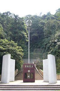
The first Geographic Center of Taiwan monument was constructed at the base of Mount Hutou (虎頭山) in the 1970s. Using a more modern land survey technique, a newer monument was built later on at the peak of the mountain.
Architecture
The first monument features an inscription by former President Chiang Ching-kuo. There are concentric steel rings on top of the monument pole, forming the basis of Puli Township logo.
The current monument was built with aborigines architectural style of columns with flare tops. The monument was built on the former site of Yoshitaka Shrine built by the Japanese.
References
Geographic Center of Taiwan Wikipedia(Text) CC BY-SA