- land 1.21 sq mi (3 km) - summer (DST) CDT (UTC-5) Area code 504 | - water 0.00 sq mi (0 km), 0% Area 3.134 km² | |
 | ||
Restaurants Fiorella's Cafe - the Original, Seasons Of Louisiana, Nick & Katie's Kitchen, Fleury of Wings, Chickie Wah Wah | ||
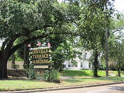
Gentilly Terrace is a neighborhood of the city of New Orleans. A subdistrict of the Gentilly District Area, its boundaries as defined by the City Planning Commission are: Filmore Avenue to the north, People's Avenue to the east, Dahlia Walk and Benefit Street to the south and Elysian Fields Avenue to the west.
Contents
- Map of Gentilly Terrace New Orleans LA USA
- Geography
- Adjacent Neighborhoods
- Boundaries
- Demographics
- Education
- Restaurants Eateries
- References
Map of Gentilly Terrace, New Orleans, LA, USA
Geography
Gentilly Terrace is located at 30°00′10″N 90°03′10″W and has an elevation of 0 feet (0.0 m). According to the United States Census Bureau, the district has a total area of 1.21 square miles (3.1 km2). 1.21 square miles (3.1 km2) of which is land and 0.00 square miles (0.0 km2) (0.0%) of which is water.
Adjacent Neighborhoods
Boundaries
The City Planning Commission defines the boundaries of Gentilly Terrace as these streets: Filmore Avenue, People's Avenue, Dahlia Walk, Benefit Street and Elysian Fields Avenue.
Demographics
As of the census of 2000, there were 10,542 people, 4,258 households, and 2,783 families residing in the neighborhood. The population density was 8,712 /mi² (3,401 /km²).
As of the census of 2010, there were 8,210 people, 3,351 households, and 2,158 families residing in the neighborhood.
Education
The Orleans Parish School Boards (OPSB) will begin the process of unifying the once fragemented school system. The OPSB will operate a portfolio of charter schools, becoming a district that oversees charter management organizations.
