
Country United States of America | ||
 | ||
River mouth Confluence with North Fork South Platte8,589 ft (2,618 m) | ||
Geneva Creek is a short tributary of the North Fork South Platte River, approximately 14.7 miles (23.7 km) long, in central Colorado in the United States. It drains part of the Rocky Mountains southwest of Denver in northern Park County. It rises at the continental divide west of Mount Bierstadt and descends through a canyon to the southeast. It joins the North Fork South Platte from the north at Grant along U.S. Highway 285. The valley of the river provides the route of the Guanella Pass Scenic Byway between Georgetown and Grant.
Map of Geneva Creek, Colorado, USA
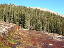
The upper part of Geneva Creek is an iron fen, where iron oxide is deposited by mineral-rich groundwater coming to the surface. The area is within the Colorado Mineral Belt, and gold and silver deposits were mined nearby at the now-deserted town of Geneva. Natural springs add high dissolved concentrations of copper and zinc to the stream.