
 | ||
Documental general zaragoza nuevo le n m xico un recorrido hist rico
General Zaragoza is a municipality and town of the northeastern Mexican state of Nuevo León. It is located in the south-eastern part of the state. The town is at 23°58′25″N 99°46′23″W. The municipality has a total area of 508 square miles (1,315 km2) and had a population of 5,942 in 2010. Most of the population lives in the town of Zaragoza. The elevation of Zaragoza is 4,520 feet (1,379 mts). Zaragoza is bordered by Aramberri, on the south and east by Hidalgo, Tamaulipas, and on the west by Doctor Arroyo.
Contents
- Documental general zaragoza nuevo le n m xico un recorrido hist rico
- Map of 67960 Gral Zaragoza Nuevo LeC3B3n Mexico
- Municipio de general zaragoza nuevo le n
- History
- Geography and climate
- References
Map of 67960 Gral Zaragoza, Nuevo Le%C3%B3n, Mexico
Zaragoza is named in honor of General Ignacio Zaragoza who fought against the French invaders at the Battle of Puebla on May 5, 1862.
Municipio de general zaragoza nuevo le n
History
The original inhabitants of the Zaragoza region were nomadic Indian bands the Spanish called Negritos or Bozalos and Janambres. In 1626, a Franciscan priest, Lorenzo Cantú from the convent at Charcas, followed a group of Indians to the valley of the Rio Blanco where he founded the Misión de San Josè del Rio Blanco near the site of Zaragoza. In 1866, the municipality of Villa de General Zaragoza was created by the government.
Geography and climate
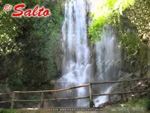
Zaragoza is at the head of the semi-arid valley of the Rio Blanco (White River), the uppermost part of the Soto La Marina River system. Some of the highest mountains of the Sierra Madre Oriental are in the Zaragoza municipality. Cerro Zaragoza which rises to 11,352 feet (3,449 mts) is three miles northeast of Zaragoza town. Cerro Peña Nevada, 11,682 feet (3,562 mts) is nine miles southwest of Zaragoza town, just across the border in Tamaulipas. Pine and Oak forests cloak the mountains. One to two miles south of town are three waterfalls—15, 20, and 25 meters high(49, 65, and 82 feet high) -- which are of interest to tourists.
In a semi-arid zone with precipitation at most locations less than 20 inches (500mm), Zaragoza is well-favored with rainfall with 28.7 inches (730mm) annually. Some of the mountains around Zaragoza receive more precipitation, including snow at higher elevations, than the town and valley. Zaragoza Este, one mile east of the town, at an elevation of 5,830 feet (1,777 mts.), receives 49.2 inches (1250 mm) of precipitation annually. Throughout the area most precipitation falls in the summer. The rainy season usually begins at the end of April and continues until the end of September. In the region around Zaragoza, August and September are usually the rainiest months. Temperatures are normally mild, although occasional days are very hot and the temperature falls below freezing several times each year.
The climatic classification of Zaragoza is Bsk (Koppen) and Bsak (Trewartha). Higher elevations near the town are cooler and more humid, some becoming Cw climates.