
Time zone UTC -3 Dial plan +598 4458 (+4 digits) Local time Saturday 3:38 PM | Founded 1914 Postal code 33002 Population 1,430 (2011) | |
 | ||
Weather 26°C, Wind E at 10 km/h, 42% Humidity | ||
General enrique mart nez puerto charqueada
General Enrique Martínez, also known as La Charqueada, is a village in the Treinta y Tres Department of eastern Uruguay.
Contents
- General enrique mart nez puerto charqueada
- Map of General Enrique MartC3ADnez Treinta y Tres Department Uruguay
- Location
- History
- Population
- Economy
- Places of worship
- References
Map of General Enrique Mart%C3%ADnez, Treinta y Tres Department, Uruguay
Location
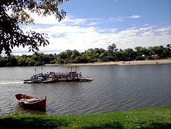
The village is located at the east end of Route 17, and the south end of Route 91, situated on the north bank of Cebollatí River and west of the mouth of the stream Arroyo del Parao. A small pontoon ferry connects across the Cebollatí River with a secondary street of 7.5 kilometres (4.7 mi), which joins it with Cebollatí of Rocha Department.
History
It was founded in April 1914 and was the head of the judicial section "Ceibos". Its status was elevated to "Pueblo" (village) on 15 October 1963 by the Act of Ley Nº 13.167.
Population
In 2011 it had a population of 1,430.
Source: Instituto Nacional de Estadística de Uruguay
Economy
The economy based on agriculture, with extensive rice fields that make up part of the landscape, livestock and fish. Tourism is also important. It has a port that served to start trade with Brazil, exporting jerky products, which prompted the town to recently be renamed (La Charqueada).