
Postal codes 5030-5032 Area code 081 | Arrondissement Namur Area codes 081 Local time Saturday 3:58 PM University Gembloux Agro-Bio Tech | |
 | ||
Weather 13°C, Wind NE at 10 km/h, 48% Humidity | ||
Gembloux ([ʒɑ̃.blu]; in Walloon: Djiblou; in Dutch: Gembloers) is a Walloon municipality located in the Belgian province of Namur, on the axis Brussels–Namur
Contents
- Map of Gembloux Belgium
- Knife exhibition gembloux 2016
- History
- Sections
- Notable inhabitants
- Twin towns
- References
Map of Gembloux, Belgium
On 1 January 2006 the municipality had 21,964 inhabitants. The total area is 95.86 km², yielding a population density of 229 inhabitants per km². The mayor, who was elected on 8 October 2006, is Benoît Dispa.
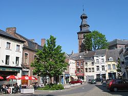
This city is well known for its Agricultural University and for its cutlery. The university is housed in the historical Abbey of Gembloux, which dates from the tenth century.
Gembloux's belfry belongs to the set of belfries of Belgium and France inscribed on UNESCO's World Heritage List in 2005.
Knife exhibition gembloux 2016
History
The town grew around the Gembloux Abbey, founded in the tenth century. In the vicinity of the town, in 1578, the Battle of Gembloux was fought during the Eighty Years' War. In May 1940 the Battle of Hannut and the Battle of the Gembloux Gap took place nearby, tank battles during the larger Battle of France.
Sections
Gembloux is composed by the sections of Gembloux, Beuzet, Bossière, Bothey, Corroy-le-Château, Ernage, Grand-Leez, Grand-Manil, Isnes, Lonzée, Mazy & Sauvenière.
Notable inhabitants
Twin towns
Gembloux is twinned with