
Highest elevation 767 m (2,516 ft) Largest settlement Jolap Elevation 767 m | Population 2,491 (2009) Area 342 km² | |
 | ||
Island groups Banks Islands, Islands of Vanuatu | ||
Vanuatu gaua island in the banks
Gaua (formerly known as Santa Maria Island) is the largest and second most populous of the Banks Islands in Torba Province of northern Vanuatu. It covers 342 km².
Contents
- Vanuatu gaua island in the banks
- Map of Gaua Vanuatu
- History
- Physical geography
- Population and languages
- Economy
- Transportation
- References
Map of Gaua, Vanuatu
History
Gaua was first sighted by Europeans during the Spanish expedition of Pedro Fernández de Quirós, from 25 to 29 April 1606. The island’s name was then charted as Santa María.
Physical geography
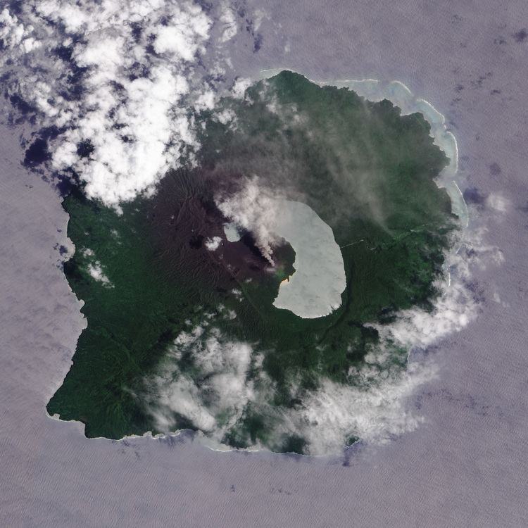
It has rugged terrain, reaching up to Mount Gharat (797 m), the peak of the active stratovolcano at the center of the island. The most recent eruption was in 2013. The volcano has a 6 × 9 km caldera, within which lies a crater lake known as Lake Letas, the largest lake in Vanuatu. To the east of the lake is Siri Waterfall (120 m drop).
Population and languages
The island has a population of 2491 (in 2009), with an annual growth rate of 2.0 percent. This population is scattered in various coastal villages on the western, southern and northeastern sides of the island. The eastern side has a few hamlets with an immigrant population coming mainly from the two smaller islands Merig and Merelava, southeast of Gaua. The largest village is Jolap, on the west coast.
Besides the language of this immigrant population (Mwerlap), there are five languages traditionally spoken on Gaua: Lakon or Vuré; Olrat; Koro; Dorig and Nume.
Economy
The population of Gaua lives of the traditional agricultural economy of Melanesia, combining fishing and horticulture. The principal exports are copra and cacao.
Transportation
The island is served by Gaua Airport at the northeast corner of the island.