
Opening date 1979 Impounds Jackson River Height 78 m Length 399 m Construction began 1974 | Type of dam Embankment, rock-fill Creates Lake Moomaw Opened December 1979 Create Lake Moomaw | |
 | ||
Width (base) 32 feet (9.8 m) (crest) 1,000 feet (300 m) (base) Operator United States Army Corps of Engineers Similar Humpback Covered Bridge, Jefferson Pools, The Homestead, Philpott Dam, Garth Newel Music Ce | ||
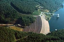
Gathright Dam is an earthen and rolled rock-fill embankment dam on the Jackson River 19 miles (31 km) north of Covington, Virginia. The dam is 257 feet (78 m) tall and 1,310 feet (400 m) long and has a controlled spillway within the structure's southern portion. It creates Lake Moomaw, which has a normal volume of 40 billion US gallons (150,000,000 m3). The dam serves flood control and recreational purposes and is operated by the U.S. Army Corps of Engineers.
Contents
- Map of Gathright Dam Hot Springs VA 24445 USA
- History and constructionEdit
- Instability concernsEdit
- References
Map of Gathright Dam, Hot Springs, VA 24445, USA
The Gathright Dam's intake tower contains nine portals that allow it to release water between reservoir depths of 12 to 87 feet (3.7 to 26.5 m). This allows the dam to manage the temperature and flow of water released downstream. This helps mitigate some of the negative environmental effects posed by the dam and manage fisheries downstream.
History and constructionEdit
The Gathright Dam was authorized by Congress with the Flood Control Act of 1946 to provide flood protection of industrial, commercial and residential properties along the Jackson and James Rivers, with immediate impact on Covington, Virginia. Benjamin Cline Moomaw, Jr., a Virginian businessman who was influential in gaining approval for the project and is known locally as "the Father of the Gathright Dam" and is the namesake for the lake. The dam itself is named after Thomas Gathright, who owned the land that was flooded by the reservoir.
Because of setbacks though, construction did not begin until 1974. The dam was finished in 1979 and that December, Lake Moomaw began to fill. The reservoir was filled by April 1982.
The reservoir reached its highest elevation in 1996 at 1,598 ft (487 m) above sea-level.
Environmentalists and the EPA challenged the plan for construction on grounds that the scenic Kincade Gorge and important historical and archaeological sites would be destroyed by the lake. Contesting parties suggested that the dam was constructed for the benefit of the Westvaco paper plant downstream that relied on a regular flow of water to operate.
Instability concernsEdit
In May 2009, the U.S. Army Corps of Engineers (USACE) inspected the Gathright Dam as part of Screening Portfolio Risk Analysis and routine inspections. Later in the year on September 2, the USACE assigned the dam a Safety Action Classification (DSAC) II which is defined as "Urgent (Unsafe or Potentially Unsafe)". The rating is attributed to concerns about possible increased seepage at the toe of the dam, and an undetermined flow rate at the river spring one-quarter mile (0.40 km) downstream, and potential flow channels through limestone below the spillway during pool events above 1,600 feet (490 m).
Because of this rating, the USACE has implemented risk reduction measures which include increased monitoring, updating emergency operation plans and reducing the water level in the reservoir. As of early 2010, the USACE has reduced and continues to maintain the reservoir at an elevation of 1,562 ft (476 m) above sea level compared to the normal level of 1,582 ft (482 m). Throughout 2010, the USACE conducted safety exercises with local/state officials, conduct a series of investigations on the dam, update inundation mapping and reevaluate the DSAC status. In November 2010, Lake Moomaw was restored to a level of 1,582 ft (482 m) and the DSAC will be reevaluated in the future.